Marble Falls Trail, Sequoia National Park
California > Sequoia National Park > Hiking > Marble Falls Trail
Marble Falls Trail
In the Foothills region of the park, this hike ascends the steep-sided canyon of the Marble Fork Kaweah River, through chaparral vegetation, to a sequence of cascades. A short off-trail continuation leads to more waterfalls
Length: 3 miles
Elevation change: 1,400 feet
Difficulty: Moderate
Type: One way
Usage: Low to medium
Season: Spring and fall - hot in summer, possibly snow-covered in winter
Trailhead: North side of Potwisha Campground, or a larger parking place on the south side of the Generals Highway
Rating (1-5): ★★★★★
Elevation change: 1,400 feet
Difficulty: Moderate
Type: One way
Usage: Low to medium
Season: Spring and fall - hot in summer, possibly snow-covered in winter
Trailhead: North side of Potwisha Campground, or a larger parking place on the south side of the Generals Highway
Rating (1-5): ★★★★★

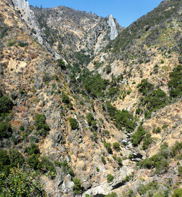
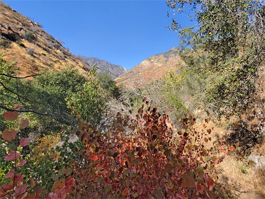
The Foothills region of Sequoia National Park is quite different to the coniferous high country that receives most attention - the hillsides here are covered by chaparral vegetation, with elevations as low as 1,500 feet, often very hot during the summer. There are still plenty of trails here, however, and perhaps the most popular is the 3 mile route to a sequence of waterfalls and cascades known collectively as Marble Falls, along the Marble Fork of the Kaweah River, so-named for the smooth white bedrock.
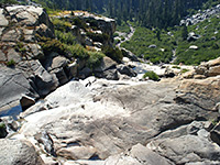
The marble is exposed in just a couple of places along the river canyon, at the falls and around half a mile above; the remainder of the rocks are a complex mix of schist, granite, diorite and granodiorite, generally dark in color. The actual Marble Falls as shown on the topological map is within the second, higher elevation outcrop; the hike visits only the first.
The path starts at Potwisha Campground, along Generals Highway (CA 180), 13 miles from Giant Forest, and stays beside the river only briefly, as the majority of the hike is traversing the hillside high above, initially quite exposed, over bushy or open slopes, becoming thickly wooded for the final mile. The path ends at a viewpoint of the main section of the cascade; more can be seen by a short off-trail continuation.
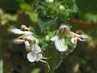
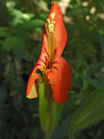
The hike offers good views all the way, passing a few jagged rock formations, and a good variety of wildflowers. Although for much of the way the terrain is generally dry, the path crosses several seasonal tributary streams where the moist conditions are good for plants.
Map of Sequoia National Park, Marble Falls Trail topo map.
14 views of Marble Falls.
Marble Falls is not signed from the highway, only from within the reservation-only campground. The trailhead is on the north side of the camp, and has a small parking area, on uneven ground, with space for around six vehicles; not suitable for RVs, and often full. There are no other parking places for day use in the campground, though plenty of room on the opposite side of the highway, at a large lot from where a short path descends to the Middle Fork of the Kaweah River. Elevation at this location is 2,100 feet, and the vegetation includes yucca and cactus.
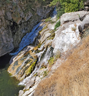
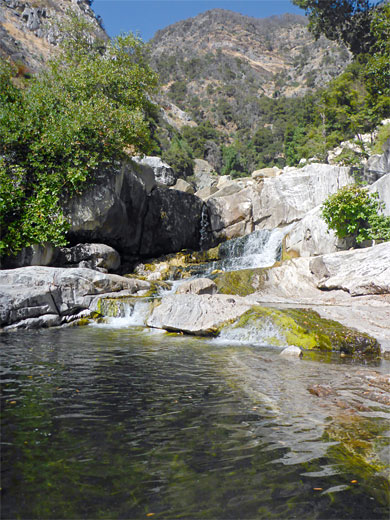
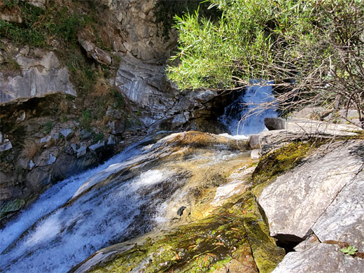
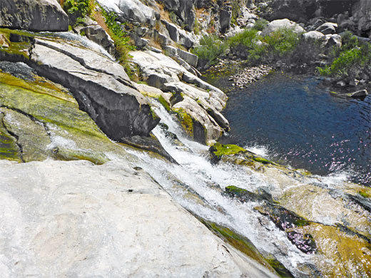
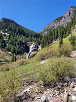
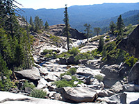
The hike is initially along a vehicle track, almost level, running northwards beside the Marble Fork river, past oaks and chaparral plants. The track parallels a concrete culvert for a while, taking water from behind a small dam. Just beyond a bridge and shortly before the end of the track, the actual trail forks off on the right, ascending via one switchback and starting a long traverse of the slopes on the east side of the valley, climbing steadily but never too steeply, always far above the canyon floor. The path crosses the first of four significant tributary streams, followed by two more in fairly quick succession, while in between and after are alternating stretches of open slopes and lesser gullies. The views are similar for 1.7 miles, up and down the canyon, until the path rounds a slight corner, through a group of schist pinnacles and enters shadier, cooler terrain, more densely wooded. The fourth tributary stream is crossed, this more likely to have flowing water all year, from a spring high above. Not far beyond is the first viewpoint of the waterfalls, the main part of which is not a single drop, rather a sloping cascade down a white slope, streaked with green algae.
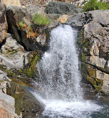
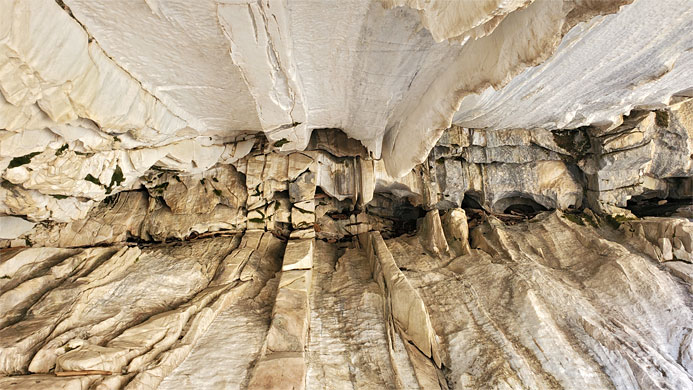
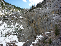
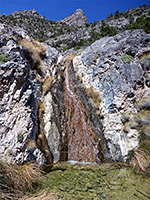
A sheer cliff rises on the far side of the falls, and there are pools and other cascades above and below. The path continues just a short way further to a bench closer to the river, from where it is possible to climb down to the brink of the main falls, and also to walk upstream, on the west side, to a larger pool below another cascade, the Upper Falls. Nearby is a photogenic alcove in the marble cliffs, the ceiling crossed by many thin ridges. The second marble outcrop containing the named Marble Falls is around a third of mile upstream, though the canyon gains almost 500 feet in this distance so it is likely to be difficult to reach.
The marble is exposed in just a couple of places along the river canyon, at the falls and around half a mile above; the remainder of the rocks are a complex mix of schist, granite, diorite and granodiorite, generally dark in color. The actual Marble Falls as shown on the topological map is within the second, higher elevation outcrop; the hike visits only the first.
The path starts at Potwisha Campground, along Generals Highway (CA 180), 13 miles from Giant Forest, and stays beside the river only briefly, as the majority of the hike is traversing the hillside high above, initially quite exposed, over bushy or open slopes, becoming thickly wooded for the final mile. The path ends at a viewpoint of the main section of the cascade; more can be seen by a short off-trail continuation.
The hike offers good views all the way, passing a few jagged rock formations, and a good variety of wildflowers. Although for much of the way the terrain is generally dry, the path crosses several seasonal tributary streams where the moist conditions are good for plants.
Location
Map of Sequoia National Park, Marble Falls Trail topo map.
Photographs
14 views of Marble Falls.
Marble Falls Video
The Trailhead
Marble Falls is not signed from the highway, only from within the reservation-only campground. The trailhead is on the north side of the camp, and has a small parking area, on uneven ground, with space for around six vehicles; not suitable for RVs, and often full. There are no other parking places for day use in the campground, though plenty of room on the opposite side of the highway, at a large lot from where a short path descends to the Middle Fork of the Kaweah River. Elevation at this location is 2,100 feet, and the vegetation includes yucca and cactus.
The Hike
The hike is initially along a vehicle track, almost level, running northwards beside the Marble Fork river, past oaks and chaparral plants. The track parallels a concrete culvert for a while, taking water from behind a small dam. Just beyond a bridge and shortly before the end of the track, the actual trail forks off on the right, ascending via one switchback and starting a long traverse of the slopes on the east side of the valley, climbing steadily but never too steeply, always far above the canyon floor. The path crosses the first of four significant tributary streams, followed by two more in fairly quick succession, while in between and after are alternating stretches of open slopes and lesser gullies. The views are similar for 1.7 miles, up and down the canyon, until the path rounds a slight corner, through a group of schist pinnacles and enters shadier, cooler terrain, more densely wooded. The fourth tributary stream is crossed, this more likely to have flowing water all year, from a spring high above. Not far beyond is the first viewpoint of the waterfalls, the main part of which is not a single drop, rather a sloping cascade down a white slope, streaked with green algae.
The Falls
A sheer cliff rises on the far side of the falls, and there are pools and other cascades above and below. The path continues just a short way further to a bench closer to the river, from where it is possible to climb down to the brink of the main falls, and also to walk upstream, on the west side, to a larger pool below another cascade, the Upper Falls. Nearby is a photogenic alcove in the marble cliffs, the ceiling crossed by many thin ridges. The second marble outcrop containing the named Marble Falls is around a third of mile upstream, though the canyon gains almost 500 feet in this distance so it is likely to be difficult to reach.

Marble Falls Trail - Similar Hikes
All Contents © Copyright The American Southwest | Comments and Questions | Contribute | Affiliate Marketing Disclosure | Site Map