The Pinnacles National Park Map shows the location of each trail.

Pinnacles National Park Trails
|
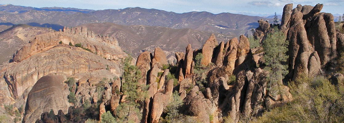
Balconies Length 1 miles (1.6 km) Elevation change 100 feet (30 meters) Trailhead Chaparral parking area Rating (1-5) ★★★★★ The Balconies are a group of volcanic ridges and domes towards the west side of the park, and provide the main destination for hikers using the Chaparral entrance. A popular path to the rocks starts at the end of the approach road, splitting into two branches at the edge of the formations; the shorter route is partly through a talus cave while the longer route (adding an extra 0.4 miles) passes large cliffs and boulders. |
|
Bear Gulch Length 1 miles (1.6 km) Elevation change 280 feet (85 meters) Trailhead Bear Gulch visitor center Rating (1-5) ★★★★★ This easy trail runs from the Bear Gulch visitor center eastwards along the wooded valley of Bear Creek to an intersection with the Bench Trail. |
|
Bench Length 2.4 miles (3.9 km) Elevation change 50 feet (15 meters) Trailhead Parking area along the approach road Rating (1-5) ★★★★★ The Bench Trail parallels the main park entrance road, starting in the east at the Pinnacles Campground and ending at a junction with the Old Pinnacles Trail. All the route is fairly level, along the valley floor, and some parts are wheelchair accessible. |
|
Chalone Peak Length 5 miles (8 km) Elevation change 2000 feet (610 meters) Trailhead Bear Gulch Reservoir, one mile from the visitor center Rating (1-5) ★★★★★ North and South Chalone Peak are the two highest points in Pinnacles National Park, and both are reached by a lengthy, fairly strenuous trail that starts from Bear Gulch Reservoir and follows high ridges most of the way. The last 1.8 miles (to the 3,269 foot southern summit) is not regularly maintained. |
Condor Gulch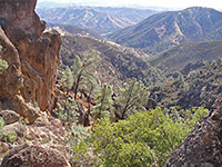 Length 1.7 miles (2.7 km) Elevation change 1100 feet (335 meters) Trailhead Bear Gulch visitor center Rating (1-5) ★★★★★ One of four paths that lead towards the main volcanic pinnacles, the Condor Gulch Trail climbs a side ravine covered by chaparral vegetation typical of the lower elevations of the park, passes an overlook (after 1 mile) with fine views west to the rocky summit and south back towards Bear Gulch, before ending at an intersection with the High Peaks Trail. |
High Peaks Trail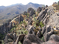 Length 5.1 miles (8.2 km) Elevation change 1500 feet (457 meters) Trailhead Bear Gulch visitor center Rating (1-5) ★★★★★ The main route into the high mountains of Pinnacles National Park, passing through the center of the largest volcanic formations around Hawkins Peak, is a moderately difficult hike that has excellent views for most of its 5 mile length. The full path starts and ends at points 1.6 miles apart, though the intersecting Condor Gulch Trail allows for a slightly shorter loop hike of 6 miles. |
|
Juniper Canyon Length 1.8 miles (2.9 km) Elevation change 1200 feet (366 meters) Trailhead Chaparral parking area Rating (1-5) ★★★★★ The Juniper Canyon Trail links the High Peaks with the western park entrance at the Chaparral ranger station, at first climbing gently along a wooded valley, then gaining height much more steeply via many switchbacks, to junctions with the Tunnel and High Peaks Trails. |
Moses Spring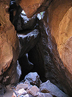 Length 1.2 miles (1.9 km) Elevation change 300 feet (91 meters) Trailhead West end of the park road Rating (1-5) ★★★★★ The best short hike in the national park is the pleasant trail up Bear Gulch, starting at the visitor center. The route encounters a clear stream, impressive rock formations, many good climbing locations, and a talus cave; it ends beside the dam forming Bear Gulch Reservoir, a good place for a picnic. Running alongside part of the main path, the Bear Gulch Cave Trail descends right through the cave, with some sections that are completely dark and require a torch. |
|
North Wilderness Length 7 miles (11.3 km) Elevation change 1000 feet (305 meters) Trailhead Chaparral parking area Rating (1-5) ★★★★★ The unmaintained, little used trail into the northern wilderness section of the park follows creekbeds most of the way, though rises to cross several ridges on the western side. The east end is at a junction with the Balconies/Old Pinnacles trails, while the west trailhead is at the Chaparral ranger station. |
|
Old Pinnacles Length 1.9 miles (3.1 km) Elevation change 300 feet (91 meters) Trailhead Chaparral parking area Rating (1-5) ★★★★★ Running alongside the West Fork of Chalone Creek, the Old Pinnacles Trail forms the shortest route to the Balconies area if starting from the east, as well as linking with the North Wilderness Trail. The path is fairly level and well shaded but not especially interesting. |
|
Rim Length 0.4 miles (0.6 km) Elevation change 80 feet (24 meters) Trailhead West end of the park road; trail begins 1 mile west Rating (1-5) ★★★★★ This link path connects the High Peaks Trail with Bear Gulch Reservoir and the end of the Moses Spring Trail, traversing a grassy hillside above Bear Gulch. |
|
South Wilderness Length 2.9 miles (4.7 km) Elevation change 200 feet (61 meters) Trailhead Near Pinnacles Campground Rating (1-5) ★★★★★ Almost all of the South Wilderness Trail is along the meandering valley of Chalone Creek, passing through patches of woodland beneath rolling hills, without any volcanic scenery. The park boundary is reached after 3 miles though the route continues, linking with other paths through the Gabilan Mountains. The hike begins along the east park road, not far beyond the entrance station. |
|
Tunnel Length 0.6 miles (1 km) Elevation change 300 feet (91 meters) Trailhead Bear Gulch visitor center; access is via the High Peaks Trail Rating (1-5) ★★★★★ Providing a slightly less scenic alternative to the steep and narrow section of the High Peaks Trail, this path also crosses the main area of rock formations, and in one place passes through a short artificial tunnel. |
All Contents © Copyright The American Southwest | Comments and Questions | Contribute | Affiliate Marketing Disclosure | Site Map