The American Southwest
Home | Parks | Trails | Plants | Canyons
Maps | Landscapes | Site Map | Whats New? |
More...
Follow americansouthwest.net on Facebook
×
General Pages
Home
Parks
Trails
Plants
Slot Canyons
Maps
Landscapes
Itineraries
Site Map
What's New?
More pages...

States
Arizona
California
Colorado
Idaho
Nevada
New Mexico
Oregon
Texas
Utah
Wyoming


ARIZONA
CALIFORNIA
COLORADO
IDAHO
NEVADA
NEW MEXICO
OREGON
TEXAS
UTAH
WYOMING
CALIFORNIA
MAPS | PARKS | TRAILS | HOTELS

Map of Mammoth Lakes


California > Mammoth Lakes > Map
Map of Mammoth Lakes

The center of Mammoth Lakes is just 3.5 miles west of US 395, but a long drive from other main towns in California. Distances to other places include Bakersfield (268 miles), Bishop (42 miles), Carson City (136 miles), Los Angeles (309 miles) and Reno (166 miles).

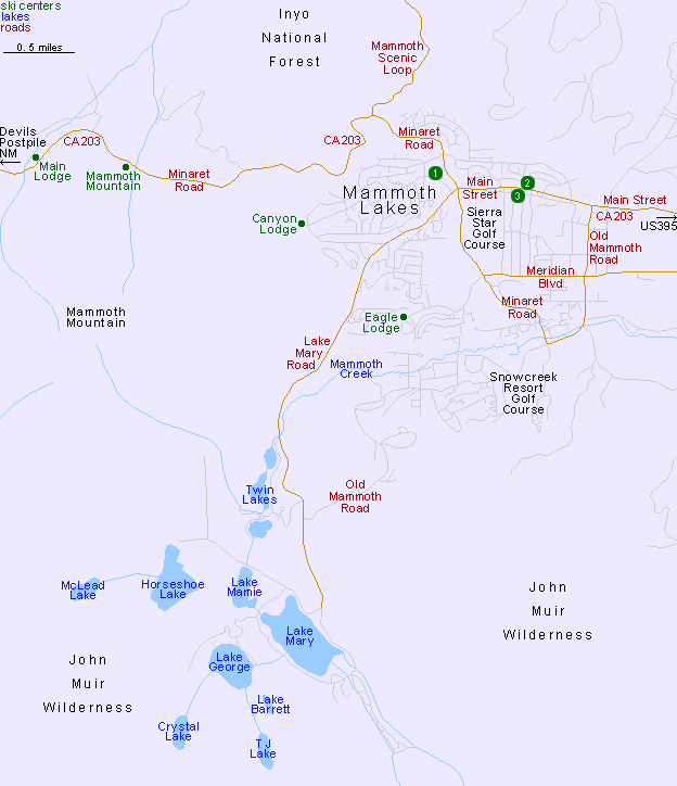
Hotels in Mammoth Lakes

1.★★★★★The Westin Monache Resort, Mammoth
2.★★★★★SureStay Plus Hotel by Best Western Mammoth Lakes
3.★★★★★Quality Inn Near Mammoth Mountain Ski Resort

See Mammoth Lakes Hotels for descriptions and photographs.

Map of Devils Postpile National Monument
Back to Top
Arizona | California | Colorado | Idaho | Nevada | New Mexico | Oregon | Texas | Utah | Wyoming | Slot Canyons | Travelogue | SOUTHWEST

All Contents © Copyright The American Southwest | Comments and Questions | Contribute | Affiliate Marketing Disclosure | Site Map