Rainbow Falls Trail, Devils Postpile National Monument
California > Devils Postpile National Monument > Rainbow Falls Trail
Rainbow Falls
Path across recently burnt forest then alongside the San Joaquin River to two powerful cascades - Rainbow Falls and Lower Falls, this latter within the Ansel Adams Wilderness
Length: 2 miles
Elevation change: 400 feet
Difficulty: Easy
Type: One way. Other paths branch off into the wilderness area
Usage: Medium to Rainbow Falls; low thereafter
Season: Summer
Trailhead: Parking area near the end of the road to Reds Meadow
Rating (1-5): ★★★★★
Elevation change: 400 feet
Difficulty: Easy
Type: One way. Other paths branch off into the wilderness area
Usage: Medium to Rainbow Falls; low thereafter
Season: Summer
Trailhead: Parking area near the end of the road to Reds Meadow
Rating (1-5): ★★★★★

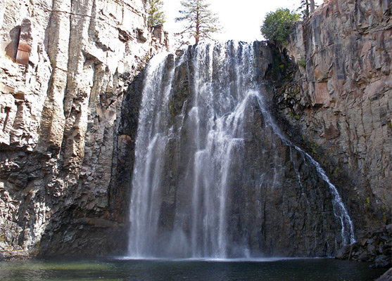
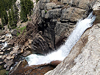
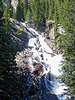
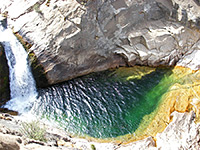
After the famous columnar formations, the other main feature of Devils Postpile National Monument is Rainbow Falls, where the Middle Fork of the San Joaquin River tumbles 100 feet over a basalt cliff in a vertical-walled canyon - a delicate sheet cascade in fall, when the water splits up into separate streams, or a raging torrent during the peak snowmelt season of early summer.
Further downstream, outside the monument, is the smaller but prettier Lower Falls, a 15 foot drop over a smooth granite rock face. Although the upper falls are on NPS land, most of the path crosses part of the Inyo National Forest, and the majority of this is within the Ansel Adams Wilderness. It is 1.3 miles to the first falls (200 feet elevation loss), then a further 0.7 miles and 200 feet down to the Lower Falls.
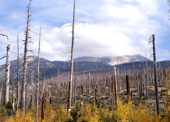
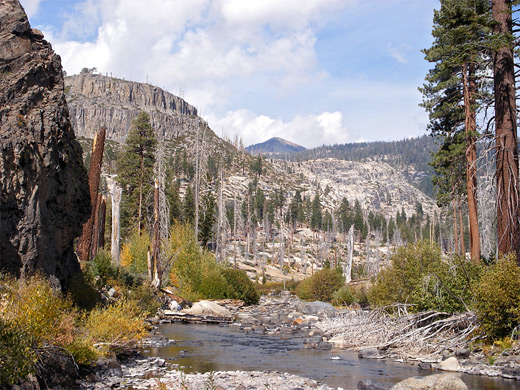
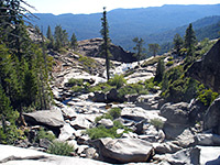
The trailhead is towards the south end of Minaret Summit Road, near shuttlebus stop number 9. From the parking area near the edge of Reds Meadow, the path descends gradually through airy forest of tall pines, past a junction with the Pacific Crest/John Muir Trail, then enters a devastated area resulting from an extensive wildfire in 1992. The hillsides for many miles in all directions are largely barren of old growth trees, bearing only burnt and broken stumps, and the surface is littered by countless decaying logs and branches, though with many healthy young trees now growing, most just a few feet tall. Regeneration is particularly good for the local bird population, which flourishes more in the young open woods than the shady mature forest. In summer, this lack of tree cover now makes hike rather hotter than might be expected, despite the high elevation and relatively gentle gradient. The trail crosses a small stream (Boundary Creek) then turns right at another junction shortly before the falls; straight on leads eventually to Fish Creek, deep in the John Muir Wilderness
The main path enters the national monument about 200 feet before the first viewpoint of Rainbow Falls - an overlook atop the basalt cliffs on the south side, a little way above the water. There is a second viewpoint just beyond, from where a spur path descends via many steps right to the base of the cascade. The falls sit in quite a narrow canyon and face northwest so are in full or partial shadow most of the day - the best time to photograph the scene is late afternoon. The water fills the whole width of the ravine and below the falls flows over a field of boulders and tree trunks, creating quite a lot of spray that floats downstream a way, forming mini rainbows when the sun shines.
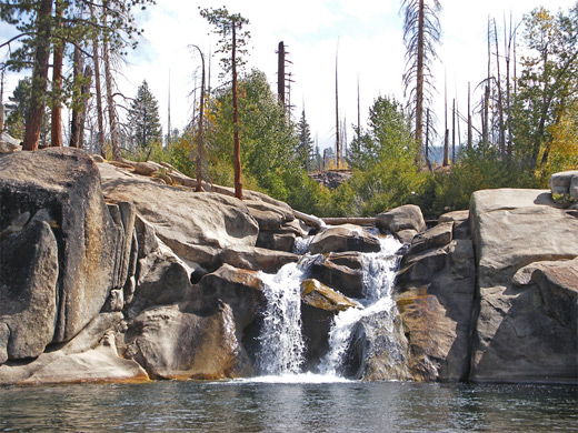
Rainbow Falls are quite popular though not so many people walk further along the path to the Lower Falls, across more fire-damaged land now generally closer to the river, which soon passes the last of the volcanic basalt rock and instead flows over the underlying granite. The lower falls are small but photogenic, a swirling drop of 15 feet over a ridge of smooth granite boulders, as the river turns west towards the high peaks of the Ritter Range, though it soon resumes its southwards course. The path ends at the edge of a pebbly beach just below the falls; the 4 mile round trip to this point and back to the parking area takes from 1.5 hours.
Further downstream, outside the monument, is the smaller but prettier Lower Falls, a 15 foot drop over a smooth granite rock face. Although the upper falls are on NPS land, most of the path crosses part of the Inyo National Forest, and the majority of this is within the Ansel Adams Wilderness. It is 1.3 miles to the first falls (200 feet elevation loss), then a further 0.7 miles and 200 feet down to the Lower Falls.

Trail to the Falls
The trailhead is towards the south end of Minaret Summit Road, near shuttlebus stop number 9. From the parking area near the edge of Reds Meadow, the path descends gradually through airy forest of tall pines, past a junction with the Pacific Crest/John Muir Trail, then enters a devastated area resulting from an extensive wildfire in 1992. The hillsides for many miles in all directions are largely barren of old growth trees, bearing only burnt and broken stumps, and the surface is littered by countless decaying logs and branches, though with many healthy young trees now growing, most just a few feet tall. Regeneration is particularly good for the local bird population, which flourishes more in the young open woods than the shady mature forest. In summer, this lack of tree cover now makes hike rather hotter than might be expected, despite the high elevation and relatively gentle gradient. The trail crosses a small stream (Boundary Creek) then turns right at another junction shortly before the falls; straight on leads eventually to Fish Creek, deep in the John Muir Wilderness
Rainbow Falls
The main path enters the national monument about 200 feet before the first viewpoint of Rainbow Falls - an overlook atop the basalt cliffs on the south side, a little way above the water. There is a second viewpoint just beyond, from where a spur path descends via many steps right to the base of the cascade. The falls sit in quite a narrow canyon and face northwest so are in full or partial shadow most of the day - the best time to photograph the scene is late afternoon. The water fills the whole width of the ravine and below the falls flows over a field of boulders and tree trunks, creating quite a lot of spray that floats downstream a way, forming mini rainbows when the sun shines.
Lower Falls
Rainbow Falls are quite popular though not so many people walk further along the path to the Lower Falls, across more fire-damaged land now generally closer to the river, which soon passes the last of the volcanic basalt rock and instead flows over the underlying granite. The lower falls are small but photogenic, a swirling drop of 15 feet over a ridge of smooth granite boulders, as the river turns west towards the high peaks of the Ritter Range, though it soon resumes its southwards course. The path ends at the edge of a pebbly beach just below the falls; the 4 mile round trip to this point and back to the parking area takes from 1.5 hours.
Rainbow Falls Trail - Similar Hikes

All Contents © Copyright The American Southwest | Comments and Questions | Contribute | Affiliate Marketing Disclosure | Site Map