Natural Bridge Trail, Yellowstone National Park
Wyoming > Yellowstone National Park > The East > Hiking > Natural Bridge Trail
Natural Bridge
Short, forested trail, partly along an old vehicle track, to a small rhyolite natural bridge, framing a minor stream
Length: 1.25 miles
Elevation change: 100 feet
Difficulty: Easy
Type: One way
Usage: High
Season: Spring, summer, fall
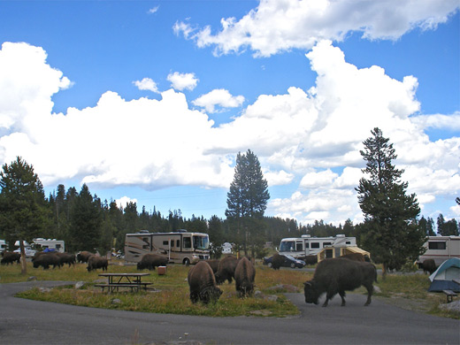
Trailhead: Bridge Bay Marina, beside the campground
Rating (1-5): ★★★★★
Elevation change: 100 feet
Difficulty: Easy
Type: One way
Usage: High
Season: Spring, summer, fall
Trailhead: Bridge Bay Marina, beside the campground
Rating (1-5): ★★★★★

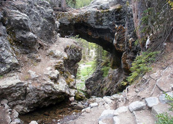
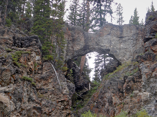
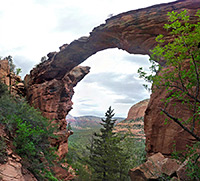
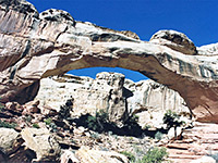
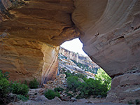
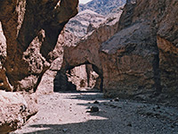
Bridge Creek is an insignificant drainage that starts on the upper slopes of Elephant Back Mountain and flows down a densely wooded valley towards Yellowstone Lake, at one point cascading over the edge of a rhyolite plateau, where the waters have carved a small natural bridge - an opening 30 feet across, topped by a narrow span of dark-colored, lichen-covered rock, on which grows a lone pine tree.
The bridge is not one of Yellowstone's major attractions but the 1.5 mile trail is popular as it starts right next to Bridge Bay Marina and Campground, and is the only path reachable from here without driving. Most of the hike is along an old paved road, in use until the early 1990s after which the route was closed to vehicles, so the hike is very easy, and the round trip takes less than an hour. The trail is closed for a month in early summer since grizzly bears frequent the area, hunting for spawning trout in the creek.
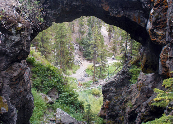
The official trailhead for the natural bridge hike is at Bridge Bay Marina, next to the carpark, though there is an alternative start point at a much smaller parking area along the highway, near the creek, at the intersection with the disused road. This route is signposted only as a bike trail; people on foot are advised to use the main parking area at the marina, from where the path begins by skirting around the edge of the forest bordering Bridge Bay, passing through old, undamaged woodland of large, well separated lodgepole pine trees. After a slight uphill grade, the trail veers right and follows a partly paved track to a junction with the other route from the highway, which then continues westwards past meadows surrounding the creek to a second junction, at the start of a short loop. The right fork soon leads to a viewpoint beneath the bridge, where the stream flows over the edge of a volcanic plateau about 70 feet above.
The best views are from behind the bridge, looking back down through the opening, a location reached by a narrower continuation trail that zig-zags quite steeply up the cliff face and crosses the stream just upstream of the opening, returning down the hillside to the south. Signs warn against walking over the bridge, which is about four feet thick at its narrowest point, and carpeted by stones and fallen branches. Beneath, the waters flow down a bouldery chute, edged by moss and ferns, an area closed to hiking in order to protect the delicate environment.
The bridge is not one of Yellowstone's major attractions but the 1.5 mile trail is popular as it starts right next to Bridge Bay Marina and Campground, and is the only path reachable from here without driving. Most of the hike is along an old paved road, in use until the early 1990s after which the route was closed to vehicles, so the hike is very easy, and the round trip takes less than an hour. The trail is closed for a month in early summer since grizzly bears frequent the area, hunting for spawning trout in the creek.
The Trail
The official trailhead for the natural bridge hike is at Bridge Bay Marina, next to the carpark, though there is an alternative start point at a much smaller parking area along the highway, near the creek, at the intersection with the disused road. This route is signposted only as a bike trail; people on foot are advised to use the main parking area at the marina, from where the path begins by skirting around the edge of the forest bordering Bridge Bay, passing through old, undamaged woodland of large, well separated lodgepole pine trees. After a slight uphill grade, the trail veers right and follows a partly paved track to a junction with the other route from the highway, which then continues westwards past meadows surrounding the creek to a second junction, at the start of a short loop. The right fork soon leads to a viewpoint beneath the bridge, where the stream flows over the edge of a volcanic plateau about 70 feet above.
The Natural Bridge
The best views are from behind the bridge, looking back down through the opening, a location reached by a narrower continuation trail that zig-zags quite steeply up the cliff face and crosses the stream just upstream of the opening, returning down the hillside to the south. Signs warn against walking over the bridge, which is about four feet thick at its narrowest point, and carpeted by stones and fallen branches. Beneath, the waters flow down a bouldery chute, edged by moss and ferns, an area closed to hiking in order to protect the delicate environment.
Natural Bridge Trail - Similar Hikes
All Contents © Copyright The American Southwest | Comments and Questions | Contribute | Affiliate Marketing Disclosure | Site Map