Utah National Forests (USFS)
Utah has six national forests, plus small sections of two whose main portion is in Idaho (Caribou-Targhee and Sawtooth) - together totaling about 15% of the land in the state. Most of the national forest area covers the central mountains, running south to north from St George all the way to the Idaho border; also included are the east-west Uinta Range, and two smaller ranges in the southeast (the Abajo and La Sal Mountains).
Other Utah listings: national parks and monuments and state parks.
Most of the Uinta Mountains of northeast Utah fall within the Ashley National Forest, together with a section of hilly, wooded land further south, bordering the Uintah-Ouray Indian Reservation - a total of 1.38 million acres, ranging in elevation from 13,528 feet (Kings Peak) to around 6,000 feet. The most visited region is around Flaming Gorge Reservoir, reached via US 191 which crosses the national forest near its east edge; apart from this, access to the area is limited to long unpaved tracks. For backpackers, the main destination is the High Uintas Wilderness, covering much of the Uinta range. A small portion (7%) of Ashley National Forest extends into Wyoming. |
|
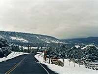
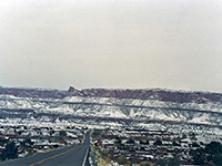
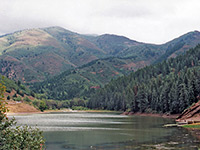
Dixie National Forest covers about 3,000 square miles of southwest Utah, in four separate units bordering four of the main parks in the area - Cedar Breaks, Bryce Canyon, Grand Staircase-Escalante and Capitol Reef - and having comparable scenery of canyons, mountains and eroded rock formations, although much of the land is dense forest. Major access routes are UT 12 between Long Valley and Torrey, and UT 14/UT 143 around Cedar Breaks, all linking with an extensive network of lesser tracks. Description | Photographs |
|
The four components of Fishlake National Forest contain wooded, mountainous land in west central Utah, split by interstate 70. The largest section covers the Pahvant Range and the Tushar Mountains, bordered by the Sevier River to the east and I-70 to the west. Further east, the national forest includes most of the Sevier Plateau, extending along the Fremont River to the boundary of Capitol Reef National Park. Another portion (Canyon Mountains) is further north, between Delta and Fillmore. There are numerous lakes, streams and summits in these areas, though few sites of particular interest. |
|
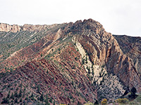
Manti-La Sal National Forest extends for 1.41 million acres in three sections of central and southeast Utah, plus a small part of west Colorado. The main area covers the peaks and valleys of the Wasatch Plateau, west of Price in the middle of the state. The second largest component contains the Abajo Mountains in the southeast, a compact range rising to 11,360 feet, and surrounded by much scenic wilderness including Dark Canyon, Canyon Rims, Grand Gulch Plateau and Comb Ridge. The other section is further north close to Moab and Arches National Park - this includes the La Sal Mountains, also relatively isolated yet quite easily accessed by many forest tracks. |
|
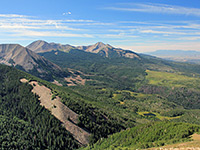
The southern end of the Wastach Range is the main landscape feature of the Uinta National Forest, from Mount Nebo near Nephi northwards to American Fork Canyon and Mount Timpanogos, extending eastwards to the boundaries of the Fishlake and Wasatch-Cache national forests (this latter is now administered as a single unit with Uinta). The 880,000 acres have many roads, tracks, trails, campsites, ski areas, and reservoirs suitable for boating and fishing, so the forest is a major center for recreation, year round. |
|
| Wasatch-Cache National Forest Recently combined with the Uinta National Forest to create a protected reserve of 2.5 million acres, Wasatch-Cache is the closest national forest to Salt Lake City and contains a wealth of scenic locations, trails and other recreation sites, including seven wilderness areas. The forest has a few outlying sections near the Salt Lake Desert but most of the area covers the northern Wasatch Range and the south end of the Bear Lake Range. Another component extends across the north side of the Uinta Mountains into Wyoming. |
All Contents © Copyright The American Southwest | Comments and Questions | Contribute | Affiliate Marketing Disclosure | Site Map