Highlights:
Narrow promontory above the confluence of the Green and Yampa rivers, reached by a scenic, paved road, the main route into the canyon country that makes up most of Dinosaur National Monument
Location:
40.524, -109.019 (end of the road)

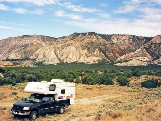
The paved road to Harpers Corner, high above the confluence of the Green and Yampa rivers at the center of Dinosaur National Monument, starts near the little town of Dinosaur, on US 40. The residents are keen to make the most of their famous association and have named the town's north-south streets Tyrannosaurus Trail, Triceratops Terrace, Allosaurus Lane, etc, as well as placing several large plastic dinosaurs at strategic places. Harpers Corner Road branches off 2 miles east of town, heading northwards into a range of low desert hills. The monument headquarters is located just by the junction, together with the Canyon Area visitor center, a picnic area, and the short Cold Desert nature trail, though no campground.
All 30 miles of Harpers Corner Road are within the national monument, as the boundaries have been defined so as to include a narrow corridor several meters wide at either side, although for most of its length the highway crosses BLM land - a rolling landscape of distant cliffs and treeless plateaus - and the main part of the monument is not reached for 24 miles (see map). Standard NPS rules apply to the whole of the road, including no camping along the way, though this is permissible on several side tracks, in particular county route 16 which crosses the highway after 11.5 miles.
All 30 miles of Harpers Corner Road are within the national monument, as the boundaries have been defined so as to include a narrow corridor several meters wide at either side, although for most of its length the highway crosses BLM land - a rolling landscape of distant cliffs and treeless plateaus - and the main part of the monument is not reached for 24 miles (see map). Standard NPS rules apply to the whole of the road, including no camping along the way, though this is permissible on several side tracks, in particular county route 16 which crosses the highway after 11.5 miles.
Harpers Corner Table of Contents
Photographs
13 views along Harpers Corner Road.
BLM Land - the first 24 miles
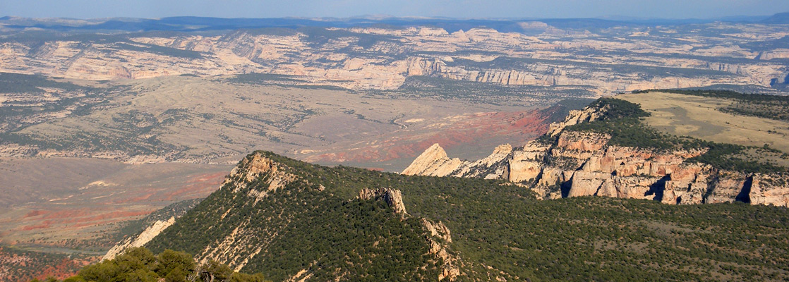
From the visitor center, Harpers Corner Road winds along a shallow ravine, crosses a grassy plain then climbs to the top of a plateau, arriving at Plug Hat Rock picnic area after 4 miles. This consists of a sheltered layby in a patch of bushes out of sight of the highway, and has several tables right on the west rim of the plateau, affording nice views over many miles of wooded, canyon and plateau land towards Jensen and the Green River. From here starts the off-trail hike to the slot canyon of Buckwater Draw. On the far side of the road, the 0.3 mile Plug Hat Trail leads to another fine viewpoint on the south edge of the cliffs. The next overlook (Escalante) has similar westward views of distant canyons, and of a colorful, stratified escarpment (Cliff Ridge) that rises 1,500 feet a few miles to the north. The junction with county route 16 (Blue Mountain Road) is reached soon after; a short drive west along this good quality gravel track reaches several areas suitable for camping that also have far reaching views, before the road descends into more wooded, undulating land beneath Cliff Ridge and reaches US 40 after 12 miles, so providing a scenic, less-traveled alternative to the main highway when driving to Harpers Corner from Jensen. The final viewpoint on Harpers Corner Road before the national monument boundary is Canyon Overlook, where for the first time the great expanse of wilderness to the east is visible, including Yampa Bench, the Yampa River canyon and many distant mountains. The overlook is reached by a short side road that crosses BLM land and splits into two; the northernmost point is quite sheltered, hidden from the highway, and equipped with rest room and picnic tables, so would be an excellent place for overnight parking, though as it lies just inside the NPS boundary, this is probably not allowed.
NPS Land - the last 6 miles
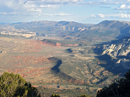
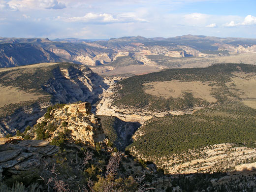
Past the Dinosaur National Monument boundary, the scenery along Harpers Corner Road becomes more steadily more impressive as the route climbs gradually and approaches the river canyons. There is one viewpoint of the Green River to the west (Island Park Overlook), though the terrain is rather dull and uniform - many distant, indistinct ridges and ravines; instead, the most amazing and extensive views are to the east, towards the Yampa River - here the red, green and white landscape stretches for miles over numerous cliffs, benches and canyons, crossed by just one rough track, the Echo Park Road. The park is a small oasis right by the Yampa-Green river confluence; in this spectacular location there is a campsite for those able to make the steep 13 mile descent along the track, which joins Harpers Corner Road just south of the NPS boundary. The two east-facing viewpoints along the main highway are the Iron Springs Bench and Echo Park overlooks, before the road reaches its final destination at Harpers Corner.
Harpers Corner
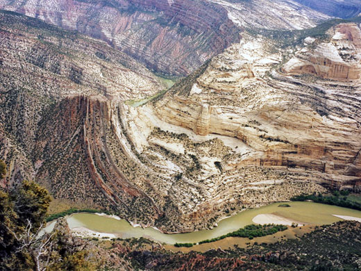
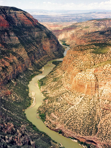
The road ends on a narrowing ridge, 7,625 feet elevation, with great views of the Green River as it flows west and enters Whirlpool Canyon. An easy one mile trail continues to the very end of the ridge, descending slightly and winding through rocky areas with pine trees and cacti. The path finishes at a point where the ridge is only a few meters wide and the views stretch for 360° - far below the three canyon systems twist away from the river confluence point, each leading into remote, inaccessible terrain. A safety fence surrounds the viewpoint at the end of the trail although the ridge does extend a little further and it is possible to continue, climbing down amongst large boulders but eventually the rocks become too unstable and the panorama is no better.
All Contents © Copyright The American Southwest | Comments and Questions | Contribute | Affiliate Marketing Disclosure | Site Map