Chesler Park, Canyonlands National Park
Utah > Canyonlands National Park > The Needles > Hiking > Chesler Park

Chesler Park
Loop hike over varied, colorful terrain of ravines, slickrock and ridges, including Chesler Park, an unspoilt meadow ringed by the jagged, red and white rocks of the Needles. One section (the Joint Trail) passes though a very narrow, slot-like ravine
Length: 2.6 miles one-way to the first viewpoint; 10.5 miles for the full loop
Elevation change: Level overall, but about 1,200 feet total elevation gain
Difficulty: Moderate
Type: Loop. Several trails branch off, allowing for longer or shorter hikes
Usage: Medium to Chesler Park; low beyond
Season: All year, though summers are very hot
Trailhead: End of the Elephant Hill Access Road
Rating (1-5): ★★★★★

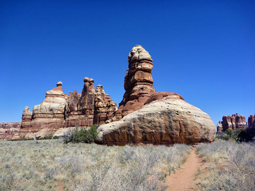
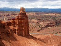
There are no roads into the heart of the Needles in Canyonlands National Park, but this place can be reached by a few miles hiking, along one of several trails. The usual destination for an all or half-day hike is Chesler Park, a large circular meadow enclosed by some of the tallest rocks in the area, displaying the characteristic red and white colors of the Cedar Mesa sandstone that covers this section of the national park.
The shortest path begins at the end of a gravel road from Squaw Flat Campground, reaching an elevated viewpoint at the edge of Chesler Park in 2.6 miles. This is the destination for many visitors, but the hike can be continued along a 5.3 mile loop which crosses the east side of the meadow, runs through a deep, narrow ravine (the Joint Trail) and traverses undulating terrain around Chesler Canyon before turning back north, climbing through a narrow pass and returning to the viewpoint; the total round trip distance from the trailhead is 10.5 miles.
The hiking is mostly fairly easy, in cooler times of year, but the hike is best avoided during the heat of summer, as there is no water en route, and not much shade. Some of the southernmost parts of the route are steeper, little used and somewhat difficult to follow, but the majority is well-used, signposted at junctions, marked by piles of stones at intervals and passes over slickrock where possible to avoid disturbing the cryptobiotic crust and so to prevent soil erosion. For people on multi-day hikes, the NPS allows camping in several sites on the meadow, along the eastern edge. Some parts of the loop are a little repetitive but overall this is an excellent hike, the best parts being the Joint Trail and the inner edges of Chesler Park.
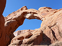
The trailhead, also the start of the Elephant Hill Jeep Trail and the long path to Red Lake Canyon, is reached by a 3 mile gravel track west of Squaw Flat Campground, a route which is narrow and unpaved but usually fine for all cars and small RVs. The 2.6 mile trail to Chesler Park heads due south, starting with a steep section but then staying mostly flat for a mile as it runs alongside a line of large pinnacles. The first junction is with a longer (3.5 mile) alternative approach from the campground, soon after which the trail leads through a deep, cave-like cleft between two sandstone mounds for about 300 feet, a passage that provides welcome relief from the heat in summer. This is about 2/3 of the way to Chesler Park; the route continues across a seasonal stream in quite a deep ravine (Elephant Canyon) near several primitive campsites, up a steep rocky incline along a short side drainage, across another flatter, open section and finally up a slope to a pass in the ring of pinnacles surrounding the meadow. A second junction, in Elephant Canyon, is for the 2.5 mile path to Druid Arch, which provides an alternative entry into Chesler Park via a connecting trail that forks west after 1.3 miles.
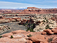
The pass gives the first view of the flat, sandy grasslands of Chesler Park, ringed on all sides by vertical pinnacles and cliffs. The scenery to the north is also spectacular, as the vantage point is high enough to overlook all the Needles district, across to the high red escarpment beyond and the La Sal Mountains on the horizon. The trail continues a short distance, descending slightly, to a junction beside an isolated group of tall spires, at the start of the 5.3 mile loop. Turning left, the next section is flat, open and exposed, crossing grassy mounds and a few dry washes, to the edge of the cliffs on the east side of the meadow, then veering away from the rocks back into the grass and sagebrush to another junction, with the connecting path from Elephant Canyon and Druid Arch. The loop path continues southwest, around the edge of an intermediate ridge into the main section of Chesler Park and across the highest point; rocks on the opposite side are somewhat lower, so the views extend all the way to the red cliffs of the Maze district.
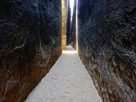
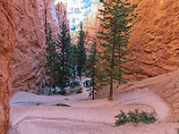
The path curves round a U-bend, past the long disused route to Virginia Park, a similar but smaller scale version of Chesler Park which has been closed to all access for several decades, as the NPS wish to protect the unspoilt environment within. After crossing more bushy ground, a short side track climbs slightly to a slickrock viewpoint on the south edge of the meadow, while the main route descends into a long, deep, narrow crevice. This is the start of the Joint Trail, the most unusual section of the loop, where for 1,000 feet the path follows a dark, vertical-walled ravine, very much like a slot canyon, though the walls are always straight and smooth so there are no varieties of color or light, and the drainage is not so pretty. Entry is via a few steps down the shallow north end of the crack, and the route is all along the mostly sandy floor, between walls of dark sandstone. Two narrow tributaries join at right angles, one (on the west side) itself quite extensive. The path drops down over some boulders, and later via a log with foot holes wedged in an 8 foot dryfall; the ravine is now about 60 feet deep but just 2 feet across.
Several other tributaries join, mostly steeply sloping, before the path reaches a wider, lighter passage with a huge boulder ahead, where it turns right, through a cave-like grotto decorated by dozens of cairns. After climbing through a little pass, the land slopes down to a sunny, open ravine and the trail rounds a corner, crosses a ridge, descends to a wide wash running through Chesler Canyon and traverses a sandy hill to a parking area at the end of a jeep track. The landscape is now subtly different - a little more open, still with pinnacles and ridges, but in smaller, less regular groups, this being close to the south edge of the Needles, where beyond the land becomes higher in elevation, flatter and more wooded.
The jeep track at the south end of the Joint Trail is a spur of the long route from Devils Lane to Beef Basin in Canyon Rims Recreation Area. The next part of the Chesler Park loop follows the track, over level, sandy ground to a junction, signed Beef Basin left. To the right, a trail soon forks off, just before a dry wash crossing; ahead is a dramatic line of pinnacles, the tallest and widest group in the whole Needles district, the far (north) side of which is visible from the park road. The trail ascends uneven, rocky terrain to another junction, close to the base of the spires. The topographic map of this area shows yet another intersection shortly before, with a path into the southwest corner of Chesler Park, but this seems no longer to be visible.
At the signed junction, the left path continues northwards through a pass in the pinnacles and over mostly open ground to Devils Pocket, where it meets routes to Elephant Hill and Red Lake Canyon. The right path is the last segment of the Chesler Park loop, first climbing to a good viewpoint on a rocky bench then descending a little, crossing a drainage and gaining height again, steeply, towards a seemingly continuous, sheer-sided ridge that forks south off the main line of pinnacles, but a narrow gap gives easy entrance into the west side of Chesler Park. Beyond, the route descends gently and offers straightforward, level walking along the north edge of the park, through several large, isolated groups of spires, on to the junction at the start of the loop, from where the Elephant Hill trailhead is 2.6 miles north.
The shortest path begins at the end of a gravel road from Squaw Flat Campground, reaching an elevated viewpoint at the edge of Chesler Park in 2.6 miles. This is the destination for many visitors, but the hike can be continued along a 5.3 mile loop which crosses the east side of the meadow, runs through a deep, narrow ravine (the Joint Trail) and traverses undulating terrain around Chesler Canyon before turning back north, climbing through a narrow pass and returning to the viewpoint; the total round trip distance from the trailhead is 10.5 miles.
The hiking is mostly fairly easy, in cooler times of year, but the hike is best avoided during the heat of summer, as there is no water en route, and not much shade. Some of the southernmost parts of the route are steeper, little used and somewhat difficult to follow, but the majority is well-used, signposted at junctions, marked by piles of stones at intervals and passes over slickrock where possible to avoid disturbing the cryptobiotic crust and so to prevent soil erosion. For people on multi-day hikes, the NPS allows camping in several sites on the meadow, along the eastern edge. Some parts of the loop are a little repetitive but overall this is an excellent hike, the best parts being the Joint Trail and the inner edges of Chesler Park.


Chesler Park Trailhead
The trailhead, also the start of the Elephant Hill Jeep Trail and the long path to Red Lake Canyon, is reached by a 3 mile gravel track west of Squaw Flat Campground, a route which is narrow and unpaved but usually fine for all cars and small RVs. The 2.6 mile trail to Chesler Park heads due south, starting with a steep section but then staying mostly flat for a mile as it runs alongside a line of large pinnacles. The first junction is with a longer (3.5 mile) alternative approach from the campground, soon after which the trail leads through a deep, cave-like cleft between two sandstone mounds for about 300 feet, a passage that provides welcome relief from the heat in summer. This is about 2/3 of the way to Chesler Park; the route continues across a seasonal stream in quite a deep ravine (Elephant Canyon) near several primitive campsites, up a steep rocky incline along a short side drainage, across another flatter, open section and finally up a slope to a pass in the ring of pinnacles surrounding the meadow. A second junction, in Elephant Canyon, is for the 2.5 mile path to Druid Arch, which provides an alternative entry into Chesler Park via a connecting trail that forks west after 1.3 miles.

Chesler Park
The pass gives the first view of the flat, sandy grasslands of Chesler Park, ringed on all sides by vertical pinnacles and cliffs. The scenery to the north is also spectacular, as the vantage point is high enough to overlook all the Needles district, across to the high red escarpment beyond and the La Sal Mountains on the horizon. The trail continues a short distance, descending slightly, to a junction beside an isolated group of tall spires, at the start of the 5.3 mile loop. Turning left, the next section is flat, open and exposed, crossing grassy mounds and a few dry washes, to the edge of the cliffs on the east side of the meadow, then veering away from the rocks back into the grass and sagebrush to another junction, with the connecting path from Elephant Canyon and Druid Arch. The loop path continues southwest, around the edge of an intermediate ridge into the main section of Chesler Park and across the highest point; rocks on the opposite side are somewhat lower, so the views extend all the way to the red cliffs of the Maze district.

Joint Trail
The path curves round a U-bend, past the long disused route to Virginia Park, a similar but smaller scale version of Chesler Park which has been closed to all access for several decades, as the NPS wish to protect the unspoilt environment within. After crossing more bushy ground, a short side track climbs slightly to a slickrock viewpoint on the south edge of the meadow, while the main route descends into a long, deep, narrow crevice. This is the start of the Joint Trail, the most unusual section of the loop, where for 1,000 feet the path follows a dark, vertical-walled ravine, very much like a slot canyon, though the walls are always straight and smooth so there are no varieties of color or light, and the drainage is not so pretty. Entry is via a few steps down the shallow north end of the crack, and the route is all along the mostly sandy floor, between walls of dark sandstone. Two narrow tributaries join at right angles, one (on the west side) itself quite extensive. The path drops down over some boulders, and later via a log with foot holes wedged in an 8 foot dryfall; the ravine is now about 60 feet deep but just 2 feet across.

Chesler Canyon
Several other tributaries join, mostly steeply sloping, before the path reaches a wider, lighter passage with a huge boulder ahead, where it turns right, through a cave-like grotto decorated by dozens of cairns. After climbing through a little pass, the land slopes down to a sunny, open ravine and the trail rounds a corner, crosses a ridge, descends to a wide wash running through Chesler Canyon and traverses a sandy hill to a parking area at the end of a jeep track. The landscape is now subtly different - a little more open, still with pinnacles and ridges, but in smaller, less regular groups, this being close to the south edge of the Needles, where beyond the land becomes higher in elevation, flatter and more wooded.

Chesler Park
The jeep track at the south end of the Joint Trail is a spur of the long route from Devils Lane to Beef Basin in Canyon Rims Recreation Area. The next part of the Chesler Park loop follows the track, over level, sandy ground to a junction, signed Beef Basin left. To the right, a trail soon forks off, just before a dry wash crossing; ahead is a dramatic line of pinnacles, the tallest and widest group in the whole Needles district, the far (north) side of which is visible from the park road. The trail ascends uneven, rocky terrain to another junction, close to the base of the spires. The topographic map of this area shows yet another intersection shortly before, with a path into the southwest corner of Chesler Park, but this seems no longer to be visible.

End of the Loop
At the signed junction, the left path continues northwards through a pass in the pinnacles and over mostly open ground to Devils Pocket, where it meets routes to Elephant Hill and Red Lake Canyon. The right path is the last segment of the Chesler Park loop, first climbing to a good viewpoint on a rocky bench then descending a little, crossing a drainage and gaining height again, steeply, towards a seemingly continuous, sheer-sided ridge that forks south off the main line of pinnacles, but a narrow gap gives easy entrance into the west side of Chesler Park. Beyond, the route descends gently and offers straightforward, level walking along the north edge of the park, through several large, isolated groups of spires, on to the junction at the start of the loop, from where the Elephant Hill trailhead is 2.6 miles north.

Chesler Park and the Joint Trail - Similar Hikes
All Contents © Copyright The American Southwest | Comments and Questions | Contribute | Affiliate Marketing Disclosure | Site Map