Interstate 80
East-west interstate across north Nevada, traversing a long succession of mountains and valleys; major towns en route include Reno, Fernley, Winnemucca, Battle Mountain, Elko and Wells
Length: 410 miles
Junctions: 91 exits; continues into California in the west and Utah in the east
Junctions: 91 exits; continues into California in the west and Utah in the east

The drive from California to Utah on I-80 is over 400 miles; sometimes quite busy compared with other Nevada roads but still less travelled than most interstate highways. The surrounding country is not particularly scenic yet the wide open vistas, the high desert plains and the distant, rugged mountain ranges do have considerable appeal.
Once past the cites of Reno-Sparks, the second largest population center in the state, interstate 80 climbs into a range of mountains and then passes no more large towns until Salt Lake City, about 10 hours drive away. After 60 miles the road descends to the edge of the Carson Sink, a large area of salt flats where several Nevada rivers end, as their waters spread out and evaporate. These include the Humboldt River - a wide, marshy waterway that flows next to the interstate for most of the way to Utah, and which has been used a natural route across the state since the 1840s. Several wildlife refuges around the sink protect birds and other wildlife.
After Lovelock, I-80 turns almost due north to avoid the Humboldt Mountains and passes the Rye Patch State Recreation Area, centred around a shallow lake formed by damming the Humboldt River, and which is used for fishing, boating and camping. A fee is charged if entered from the south (exit 129), but an unpaved road around the north side (exit 145) affords free access and has several good places to spend the night - enjoying sweeping views across the lake, with the slowly-moving traffic of I-80 and trains on the nearby Central Pacific railway line just discernible a few miles to the south. Other points of interest are several old mine workings, with many specimens of chrysocolla, a striking blue-green mineral.
Beyond the reservoir, the scenery alternates between mountain ranges and flatter open areas with occasional, well-separated towns; Mill City, Winnemucca, Battle Mountain, Carlin, Elko and Wells. The road has many long, straight sections with occasional bends that make cruise control very useful on this journey. At Wendover on the Nevada/Utah border, interstate 80 rounds a small range of hills and passes over a low summit revealing an immense expense of whiteness - the Great Salt Lake Desert, across which the twin carriageways forge ahead, completely straight for over 50 miles to the horizon.
The main towns with hotels along interstate 80 in Nevada are, from west to east, Reno, Sparks, Fernley, Winnemucca, Battle Mountain, Elko and Wendover. See also the list of all I-80 exits and nearby hotels.
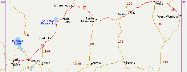
I-80 Map
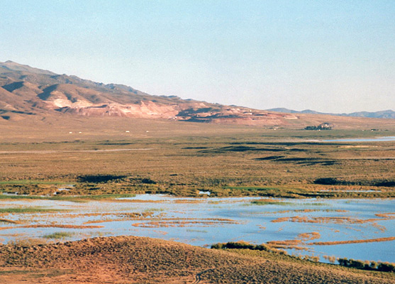
The Carson Sink
Once past the cites of Reno-Sparks, the second largest population center in the state, interstate 80 climbs into a range of mountains and then passes no more large towns until Salt Lake City, about 10 hours drive away. After 60 miles the road descends to the edge of the Carson Sink, a large area of salt flats where several Nevada rivers end, as their waters spread out and evaporate. These include the Humboldt River - a wide, marshy waterway that flows next to the interstate for most of the way to Utah, and which has been used a natural route across the state since the 1840s. Several wildlife refuges around the sink protect birds and other wildlife.
Rye Patch Reservoir
After Lovelock, I-80 turns almost due north to avoid the Humboldt Mountains and passes the Rye Patch State Recreation Area, centred around a shallow lake formed by damming the Humboldt River, and which is used for fishing, boating and camping. A fee is charged if entered from the south (exit 129), but an unpaved road around the north side (exit 145) affords free access and has several good places to spend the night - enjoying sweeping views across the lake, with the slowly-moving traffic of I-80 and trains on the nearby Central Pacific railway line just discernible a few miles to the south. Other points of interest are several old mine workings, with many specimens of chrysocolla, a striking blue-green mineral.
I-80 Towns
Beyond the reservoir, the scenery alternates between mountain ranges and flatter open areas with occasional, well-separated towns; Mill City, Winnemucca, Battle Mountain, Carlin, Elko and Wells. The road has many long, straight sections with occasional bends that make cruise control very useful on this journey. At Wendover on the Nevada/Utah border, interstate 80 rounds a small range of hills and passes over a low summit revealing an immense expense of whiteness - the Great Salt Lake Desert, across which the twin carriageways forge ahead, completely straight for over 50 miles to the horizon.
Hotels
The main towns with hotels along interstate 80 in Nevada are, from west to east, Reno, Sparks, Fernley, Winnemucca, Battle Mountain, Elko and Wendover. See also the list of all I-80 exits and nearby hotels.
All Contents © Copyright The American Southwest | Comments and Questions | Contribute | Affiliate Marketing Disclosure | Site Map