Hiking in Yellowstone National Park - the Southeast
Wyoming > Yellowstone National Park > The Southeast > Hiking
Southeast Yellowstone Trails: Day Hikes | Backcountry Hikes
The Yellowstone hiking map indicates the location of each trail.
All paths in Yellowstone: North, East, Southeast, Southwest, Northwest.

Southeast Yellowstone National Park Trails - Day Hikes along the Main Road, near West Thumb Geyser Basin
Duck Lake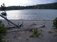 Length 0.5 miles (0.8 km) Elevation change 100 feet (30 meters) Trailhead West Thumb Geyser Basin Rating (1-5) ★★★★★ This short path passes over land recovering from the 1988 fires - starting at the parking area for the West Thumb Geyser Basin, the trail climbs a small hill to a viewpoint of Duck Lake then leads down to a beach on its north shore. |
Riddle Lake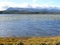 Length 1.75 miles (2.8 km) Elevation change 80 feet (24 meters) Trailhead Pullout along US 191/287 Rating (1-5) ★★★★★ From a trailhead along the main road, 2.5 miles south of Grant Village and right on the continental divide, this easy hike descends gradually through new growth lodgepole forest to the upper end of Riddle Lake. The shallow mountain lake is lined with reeds and marshland, and is a good place to spot wildlife including bear and moose. |
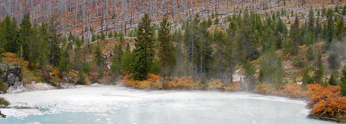
West Thumb Geyser Basin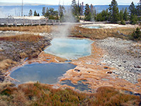 Length 0.75 miles (1.2 km) (loop) Elevation change 20 feet (6 meters) Trailhead Along the Grand Loop Road beside Yellowstone Lake Rating (1-5) ★★★★★ Two level, wheelchair accessible, intersecting loop trails pass around all the thermal features of West Thumb basin, on the shores of Yellowstone Lake. The small but very scenic geyser basin contains many hot springs and is a must-see attraction of the park. |
Yellowstone Lake Overlook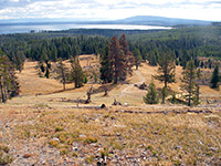 Length 1 miles (1.6 km) Elevation change 500 feet (152 meters) Trailhead West Thumb Geyser Basin Rating (1-5) ★★★★★ The second of two short hikes to viewpoints that begin from the West Thumb Geyser Basin parking area, this climbs past a few small pools and gas vents to a vantage point at the edge of a wildflower-filled meadow up in the mountains. |
Southeast Yellowstone National Park Trails - Backcountry Hikes
Heart Lake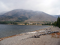 Length 16 miles (25.7 km) Elevation change 700 feet (213 meters) Trailhead End of a short track forking off US 191/287 Rating (1-5) ★★★★★ This relatively popular trail into one of Yellowstone's backcountry geyser basins also passes varied scenery of pine forest, open plateauland, mountains, river valleys and Heart Lake itself. The north end begins from the park road, opposite the northeast corner of Lewis Lake, while the south trailhead is along the South Boundary Trail, 5.5 miles east of the road. The full distance needs at least one night camping though Heart Lake Geyser Basin is easily reached on a day hike, being between 4 and 7 miles from the road. Aside from the thermal features, all unfenced and undamaged, the main attractions are the lake - the best in Yellowstone for fishing, and the wildlife, with moose and bears quite frequently encountered. |
|
Mount Sheridan Length 3.5 miles (5.6 km) Elevation change 1780 feet (543 meters) Trailhead West side of Heart Lake, 8 miles from the Grand Loop Road Rating (1-5) ★★★★★ The steep climb up the east face of 10,308 foot Mount Sheridan in the Red Mountains begins by the shores of Heart Lake, along the trail past the lake and the nearby geyser basin. |
|
Mountain Creek Length 10 miles (16.1 km) to Eagle Pass Elevation change 1370 feet (418 meters) Trailhead Along the Thorofare Trail Rating (1-5) ★★★★★ The Mountain Creek drainage is a tributary of the Yellowstone River, meeting it a few miles south of Yellowstone Lake. A little-used path branches off the Thorofare Trail and follows the creek eastwards, exiting the park at 9,320 foot Eagle Pass in the Absaroka Range, then onwards into the Washakie Wilderness. |
| Tours of Yellowstone |
|
Snake River Length 17 miles (27.4 km) Elevation change 800 feet (244 meters) Trailhead Along the South Boundary Trail Rating (1-5) ★★★★★ This trail follows the upper reaches of the Snake River, starting and finishing at intersections with the South Boundary Trail. The west end is 7 miles east of the park road, where the river curves round to the north; the path follows the marshy valley to the junction with Heart River then swings round southeast, along a narrower, steeper ravine all the way to the eastern terminus, beside the national park boundary. There are many river crossings along the route, though the water is usually just 1 or 2 feet deep by mid summer. |
|
South Boundary Length 35 miles (56.3 km) Elevation change level Trailhead By the south entrance Rating (1-5) ★★★★★ From the south entrance station along US 89/191/287, the eastern half of the South Boundary Trail heads first along the flat valley of the Snake River then up the steeper ravine of Harbell Creek, passes outside the park for a few miles over Big Game Ridge, then descends to the Snake River once more. The last 13 miles are up to Two Ocean Plateau, across the continental divide and down Lynx Creek into the Yellowstone River valley, where the path meets the lower end of the Thorofare Trail. There are only occasional minor thermal features hereabouts so the main appeal is the wild mountain scenery, but the remoteness and steep terrain mean that few people hike the full distance. |
|
Thorofare Length 33 miles (53.1 km) to the park boundary Elevation change level overall Trailhead East side of Yellowstone Lake, beside the east entrance road Rating (1-5) ★★★★★ One of the longest cross-country trails in Yellowstone, Thorofare starts at Bridger Lake in the Teton Wilderness and enters the park at the far southeast corner, next to Thorofare Creek just as it joins the Yellowstone River. The route follows the marshy river valley northwards, past the southeast arm of Yellowstone Lake then right along the eastern shore as far as the east entrance road. All of this region is very remote and seldom explored. |
|
Trail Creek Length 21 miles (33.8 km) Elevation change 400 feet (122 meters) Trailhead North side of Heart Lake Rating (1-5) ★★★★★ Running from the top end of Heart Lake past the two southern arms of Yellowstone Lake, the Trail Creek Trail is one of two cross-country routes in the southeast corner of Yellowstone. The west end is at Heart Lake from where the route follows two narrow valleys eastwards then crosses flat, marshy land as far as the Yellowstone River valley and a junction with the Thorofare Trail. |
|
Two Ocean Plateau Length 10.5 miles (16.9 km) Elevation change 1600 feet (488 meters) Trailhead Along the South Boundary Trail, beside Plateau Creek Rating (1-5) ★★★★★ Two Ocean Plateau is a range of hills marking the course of the continental divide, near the south edge of the park. Far from any main road, the trail traverses the foothills on the west side of the plateau, linking South Boundary Trail with Trail Creek Trail, which it joins just south of Yellowstone Lake. Most of the northern half is along gentle terrain beside Chipmunk Creek, though the south part is steeper, up to a ridge at 9,350 feet and down a narrow valley beyond. |
All Contents © Copyright The American Southwest | Comments and Questions | Contribute | Affiliate Marketing Disclosure | Site Map