Muir Grove Trail, Sequoia National Park
California > Sequoia National Park > Hiking > Muir Grove Trail
Muir Grove Trail
From the far side of Dorst Creek Campground (not always open), this lightly-used trail traverses wooded, sloping ground, over two tributaries of the creek, to a photogenic group of giant sequoia trees, on top of a ridge
Length: 2.2 miles, plus 1 mile if the campground is closed
Elevation change: 300 feet
Difficulty: Easy
Type: One way
Usage: Low
Season: Spring, summer, fall
Trailhead: West end of Dorst Creek Campground; or, if closed, the campground entrance
Rating (1-5): ★★★★★
Elevation change: 300 feet
Difficulty: Easy
Type: One way
Usage: Low
Season: Spring, summer, fall
Trailhead: West end of Dorst Creek Campground; or, if closed, the campground entrance
Rating (1-5): ★★★★★

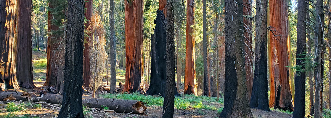
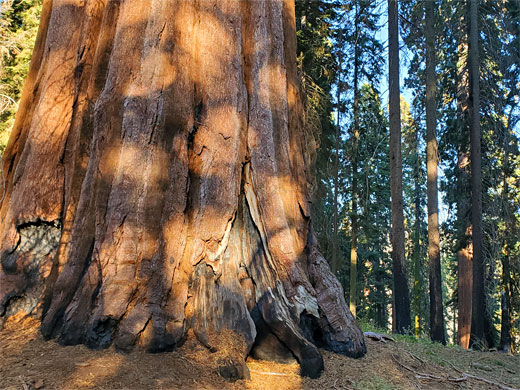
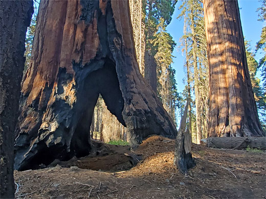
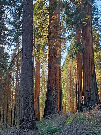
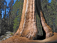
Named after naturalist John Muir, Muir Grove is one of the more remote groups of giant sequoia trees in Sequoia National Park, situated on top of a ridge towards the west side of the park, near the border with Kings Canyon, 6 miles northwest of the Giant Forest. There are several dozen old growth sequoia here plus a scattering of younger specimens, including one named tree - the Dalton Tree, supposedly the 24th largest in the park, 264 feet tall and 22 feet in diameter at the base. The elevated location on a narrow ridge allows good light all through the day, especially around sunset, and the quiet, little-visited location ensures a permanently peaceful ambience.
Muir Grove is reached by a relatively easy hike of 2.2 miles, starting from the far end of Dorst Creek Campground; the trail is fairly level overall, with a few short climbs and descents as it traverses sloping ground, crossing two tributaries of the creek, mostly through dense woodland apart from one short open section across a granite outcrop.
The campground however has a rather limited opening season, and has been completely closed since 2023 because of storm damage; reopening is not expected until 2027. The hike therefore has to start from the campground entrance along the Generals Highway, as the access road is closed by a gate, and this necessitates an extra one mile of walking; the campground is a large, dispersed facility, its various sections spread out across different parts of the forest.
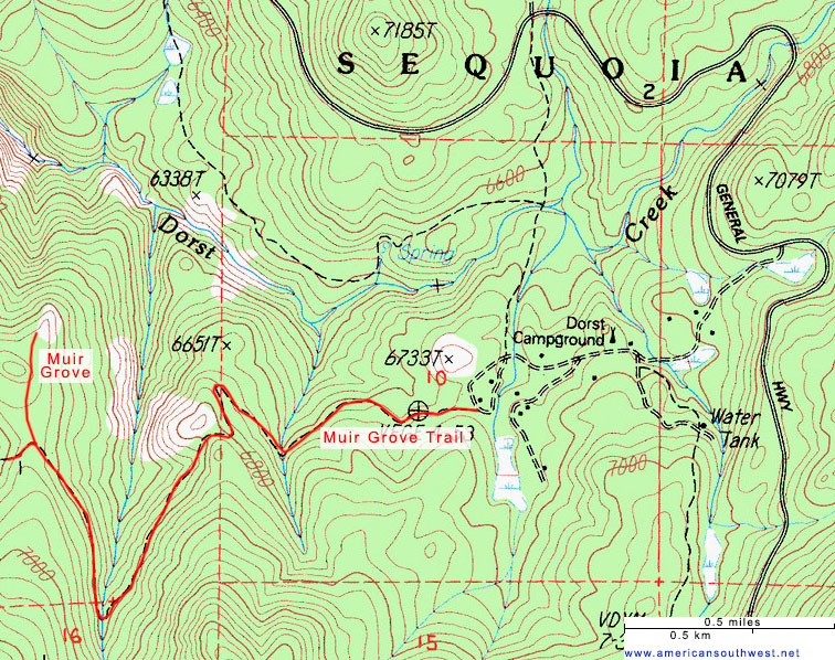
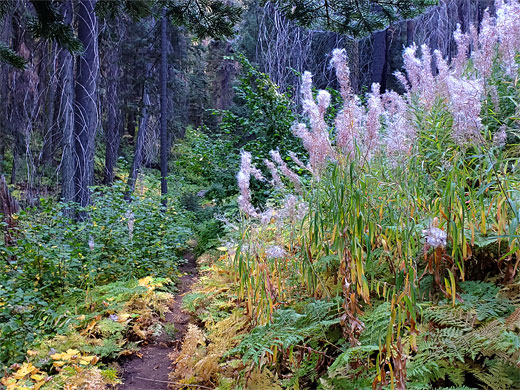
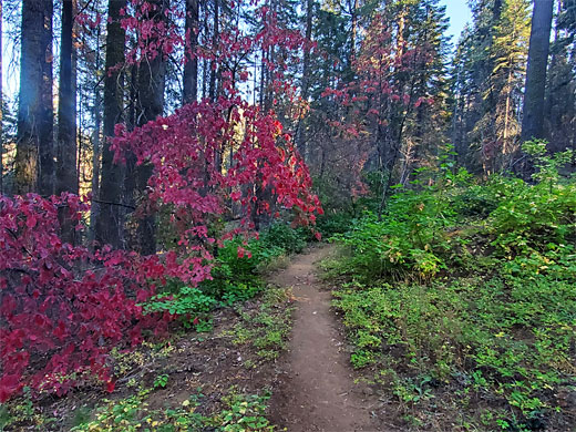
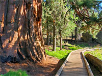
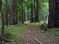
If the campground is closed, there is space for several vehicles to park at the entrance along the Generals Highway, a 12 mile drive from the Giant Forest. The campground road descends gradually, through a mix of wooded and open areas, past the various facilities, through several junctions to the furthest part, which includes some day-use parking. The trail is marked with an inconspicuous sign right at the western edge of the final campground loop. The path is narrow but easy to follow; it enters the dark woods, descends a slope to a junction, right being a route down to Dorst Creek. The left branch stays level, curving into a valley, crossing a stream, traversing the slopes on the far side then climbing via one switchback to a ridgetop, and a big slab of bare granite.
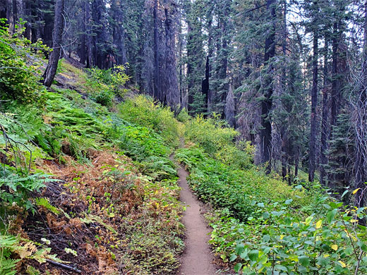
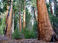
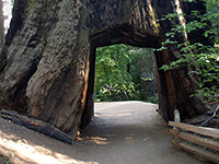
The trail moves into a larger valley, on the far side of which the sequoia grove can be seen, recognisable for being higher than the surrounding trees, and with rounded rather than pointing tops. The path has a gradual descent over a more lightly-wooded hillside, partly damaged in a 2021 wildfire, then enters thicker woodland around a second stream, lined by ferns and other lush vegetation. The final section rises slightly, still traversing steeply-sloping ground, to the top of the ridge and into the Muir Grove, which is instantly recognisable for a huge sequoia right at the entrance. One short side path heads west a way, down the far side of the ridge to some of the old trees, and another leads north through the grove, ending at a minor summit. There is at least one walk-through tree in the grove, hollow the base, and several dozen other large specimens, mingling with other conifers - white fir and sugar pine. One mile south of this location is an even more remote cluster of sequoia, the Skagway Grove, once reachable by a continuation of the path, but now the route is abandoned and unrecognizable.
Muir Grove is reached by a relatively easy hike of 2.2 miles, starting from the far end of Dorst Creek Campground; the trail is fairly level overall, with a few short climbs and descents as it traverses sloping ground, crossing two tributaries of the creek, mostly through dense woodland apart from one short open section across a granite outcrop.
The campground however has a rather limited opening season, and has been completely closed since 2023 because of storm damage; reopening is not expected until 2027. The hike therefore has to start from the campground entrance along the Generals Highway, as the access road is closed by a gate, and this necessitates an extra one mile of walking; the campground is a large, dispersed facility, its various sections spread out across different parts of the forest.
Start of the Trail
If the campground is closed, there is space for several vehicles to park at the entrance along the Generals Highway, a 12 mile drive from the Giant Forest. The campground road descends gradually, through a mix of wooded and open areas, past the various facilities, through several junctions to the furthest part, which includes some day-use parking. The trail is marked with an inconspicuous sign right at the western edge of the final campground loop. The path is narrow but easy to follow; it enters the dark woods, descends a slope to a junction, right being a route down to Dorst Creek. The left branch stays level, curving into a valley, crossing a stream, traversing the slopes on the far side then climbing via one switchback to a ridgetop, and a big slab of bare granite.
Muir Grove
The trail moves into a larger valley, on the far side of which the sequoia grove can be seen, recognisable for being higher than the surrounding trees, and with rounded rather than pointing tops. The path has a gradual descent over a more lightly-wooded hillside, partly damaged in a 2021 wildfire, then enters thicker woodland around a second stream, lined by ferns and other lush vegetation. The final section rises slightly, still traversing steeply-sloping ground, to the top of the ridge and into the Muir Grove, which is instantly recognisable for a huge sequoia right at the entrance. One short side path heads west a way, down the far side of the ridge to some of the old trees, and another leads north through the grove, ending at a minor summit. There is at least one walk-through tree in the grove, hollow the base, and several dozen other large specimens, mingling with other conifers - white fir and sugar pine. One mile south of this location is an even more remote cluster of sequoia, the Skagway Grove, once reachable by a continuation of the path, but now the route is abandoned and unrecognizable.
Topographic Map of the Muir Grove Trail
Muir Grove - Similar Hikes
All Contents © Copyright The American Southwest | Comments and Questions | Contribute | Affiliate Marketing Disclosure | Site Map