Highlights:
17 mile dirt road past the best formations of Monument Valley, within the Navajo Tribal Park, passing 11 major overlooks. Usually accessible to regular vehicles, including small RVs, though various types of guided tour are available

The drive is 17 miles long of which 13 miles is a one-way loop, and typical times for the full trip are 2 to 4 hours. 15 mph is the nominal speed limit, and some places are too rocky and bumpy to go any faster, though other sections are quite smooth (with a surface of hard pressed sand), and up to 40 mph is possible. The road can become very busy during summer days, with queues at the major overlooks; early morning is the preferred time to visit as the light is better for photography and there are far fewer people than later in the day. Opening hours are 6 am - 8 pm (May - Sep) or 8 am - 5 pm (Oct - Apr).
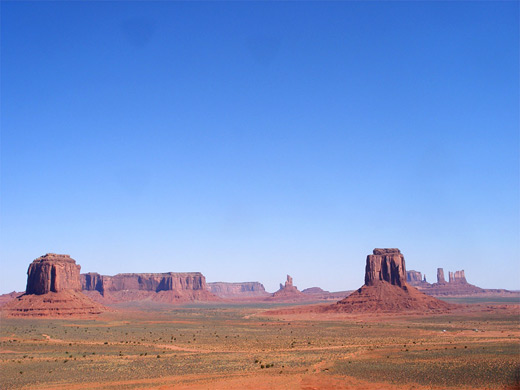
There is much to see along the Valley Drive, even if many of the views are of the same formations, just at different angles, as some of the narrower buttes look quite different from one side compared to the other. This part of Monument Valley is one of the most impressive large-scale landscapes anywhere in the Southwest, rivaling places like the Grand Canyon or Yosemite for the variety of scenes to photograph. The larger mesas are not so interesting; best are the tall spires and thin buttes, and the contrasting smooth orange sand all around, since most of the park is empty desert, crossed only by a few dry washes and sandy tracks leading to Navajo settlements.
Valley Drive Table of Contents
- Map of the drive
- Photographs
- 1. The Mittens and Merrick Butte
- 2. Elephant Butte
- 3. Three Sisters
- 4. John Ford's Point
- Tours of Monument Valley
- 5. Camel Butte and Tse Biyi
- 6. Rain God Mesa and the Hub
- 7. Totem Pole and Yei Bi Chei
- 8. Totem Pole, Spearhead Mesa and Sand Spring
- 9. Artist's Point
- 10. North Window
- 11. The Thumb
Location
Valley Drive Map - showing all viewpoints, roads and formations along the scenic drive.
Photographs
27 views along the Valley Drive.

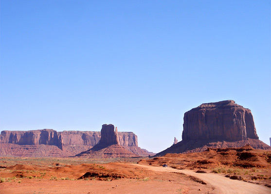
1. The Mittens and Merrick Butte
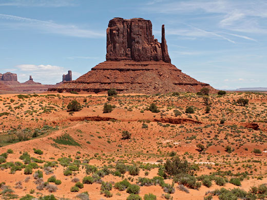
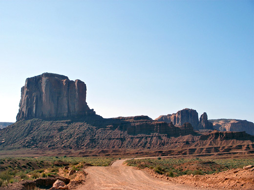
The initial descent from the visitor center includes the roughest section of the whole road, where it traverses a steep, rocky hillside via a series of switchbacks, but this difficult part is quite short and the road soon levels out, then passes by three of the most famous Monument Valley formations, all on the east side - West Mitten Butte (which may be seen close up via the 3.2 mile Wildcat Trail), Merrick Butte and East Mitten Butte. On the right side of the road, the flat land is bordered by the eastern face of Mitchell Mesa, rising 1,000 feet above. A side track forks north near Merrick Butte, but like all back roads in the park this may only be traveled as part of a Navajo guided tour.
2. Elephant Butte
The Valley Drive takes a sharp bend to the right as it approaches an area of deep red-colored badlands beneath the end of Elephant Butte, which has a high, sheer-sided block of sandstone on one side and a narrow, tapering ridge on the other. The road surface becomes quite bumpy during a short climb around the west edge of the ridge but improves thereafter. The butte does not look very much like an elephant, although the resemblance is said to improve during the afternoon, as shadows lengthen.
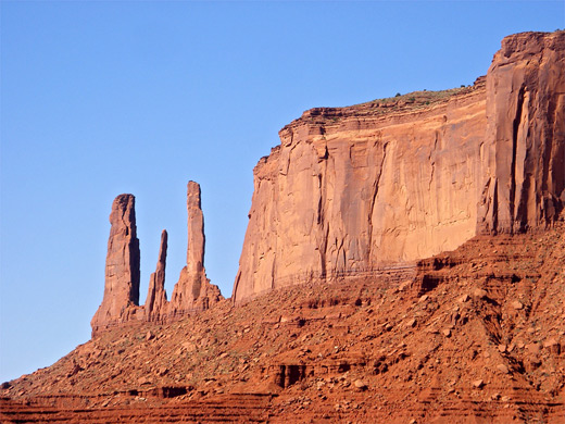
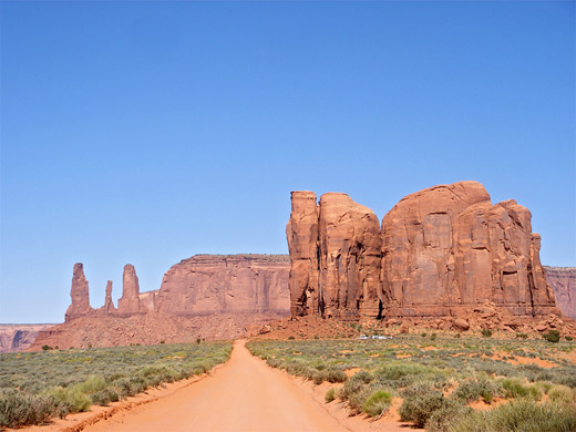
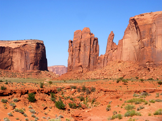
3. Three Sisters
Viewpoint number three is on the west side of the road, opposite the edge of Elephant Butte. The Three Sisters are a group of thin pinnacles, eroded remnants of a narrow ridge extending southwards from one corner of Mitchell Mesa - together with adjoining Wetherill Mesa these two flat-topped hills shield this part of Monument Valley from US 163 further west. There are several similar groups of spires elsewhere in the valley including Castle Rock, and Bear and Rabbit, a few miles north near Monument Pass. A little way south of the viewpoint, the Valley Drive arrives at a cross-roads; right is a spur road to John Ford's Point, while the main route leads straight ahead, and becomes one-way.
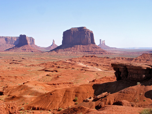
4. John Ford's Point
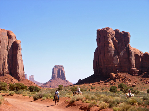
Film director John Ford used Monument Valley as a location for many Westerns between 1939 (Stagecoach) and 1960, and one site that featured often is now known as John Ford's Point - a promontory at the edge of a plateau overlooking a large area of uneven, undulating desert land around the first few miles of the Valley Drive, with several isolated peaks beyond. The main summits in view are Sentinel Mesa, West Mitten Butte, Big Indian, Merrick Butte and the Castle Rock-Stagecoach group, plus Three Sisters/Mitchell Mesa to the west and Elephant Mesa to the east. Along with Artist's Point (viewpoint number 9), this is the best overlook in the park and has a suitably large parking area to accommodate the many tour buses that stop here. A permanent Navajo jewelry store is located nearby, and visitors can recreate the iconic image of a lone rider on a horse standing at the edge of the viewpoint for just $2 per person - paid to the owner of one of the horses stationed here most of the day just for this purpose.
Monument Valley Tours
Explore Monument Valley with Navajo guides; roads are often rough, so for some, a guided tour is the best way to experience the scenery.
5. Camel Butte
The fifth stop is by the crossroads - a view of Camel Butte, another thin, narrowish sandstone peak but not one particularly interesting to look at. The road is now at its highest point, and next begins a gradual descent as the Valley Drive heads further south, running along the edge of a wide empty valley known as Tse Biyi. Several lesser tracks cross this sandy expanse but again these are not open to the general public.
6. The Hub
The next junction is reached 1.3 miles from the crossroads, where the main route bears east and enters a more confined valley between Rain God Mesa and Thunderbird Mesa. The other track leads to places in the south of the tribal park including Saddle Rock, Submarine Rock, Totem Pole, several sandstone arches, Anasazi dwellings and petroglyphs, though this section may only be visited on an escorted tour. A little way southwest of the junction, The Hub is a single, solitary spire, 150 feet high, with a cluster of Navajo dwellings at its base. There are no rocks beyond this for about 4 miles, as far as Hunts Mesa which forms the southern boundary of Monument Valley.
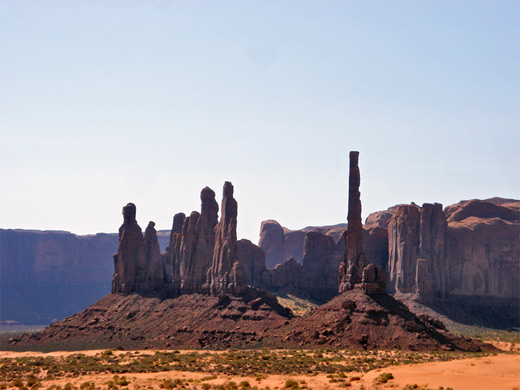
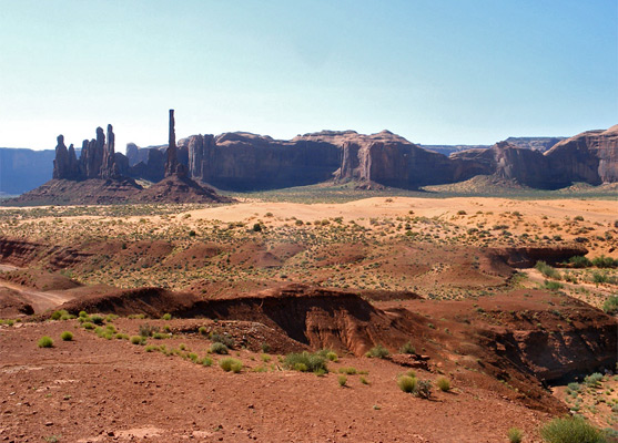
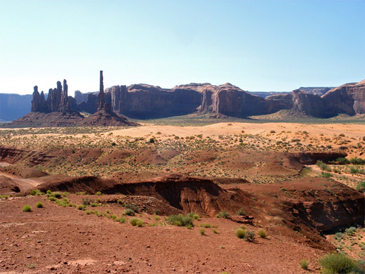
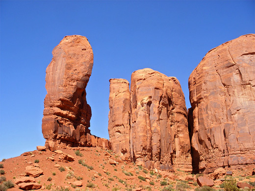
7. Totem Pole and Yei Bi Chei
The one-way loop road continues close to Rain God Mesa through increasingly sandy ground; large dunes rise up to the south, in front of the larger Thunderbird Mesa, and a shallow wash (Sand Spring, the main water source in the area) runs alongside. At the edge of the sands is another isolated group of spires (Yei Bi Chei) next to which stands one of the most well known peaks in the valley. Totem Pole is a tall, red sandstone column, 450 feet high but only 40 foot across, slightly detached from its neighbors, and pointing skywards against a backdrop of wide but more distant cliffs of the Tse Biyi Yazzie and Hunts Mesa formations. The pinnacles are quite far from the viewpoint (one mile) so not easy to photograph in detail. A closer view is possible from other tracks further south, which form part of the extended guided tour across the southern half of the park.
8. Totem Pole and Sand Spring
The next pull-out is officially a viewpoint of Sand Spring and the nearby red-orange dunes but it also gives a better perspective of Totem Pole and Yei Bi Chei, since the overlook is a little closer to these formations than stop number 7. The parking area is along a side track that branches off at the south end of Spearhead Mesa, a route that continues across a creekbed (Gypsum Wash) and on to the southern section of the park, off-limits to private vehicles. Spearhead is a multi-pointed mesa that borders the main road for a mile northwards, as far as Artist's Point. The surface of this section is often partly covered by wind blown sand that may on occasions be deep enough to cause problems for some vehicles.
9. Artist's Point
Another short spur forks north and climbs gradually to the edge of a plateau, where the ground falls away quite steeply and ahead stretch many miles of flat land punctuated by the familiar peaks of West Mitten Butte, Merrick Butte and East Mitten Butte, plus the more distant pinnacles around Monument Pass. This is Artist's Point, perhaps the second best overlook along the drive (after John Ford's Point), but one rather less visited and so more peaceful. The edge of Spearhead Mesa towers quite high above to the east, and to the west are the smaller spans of Cly Butte and Elephant Butte.
10. North Window
The penultimate stop along the Valley Drive is at North Window - a gap between the edges of Elephant Butte and Cly Butte which frames East Mitten Butte, 3 miles to the north. The parking area is just off the main road, from where visitors may walk (not drive) along a 1/3 mile track that leads closer to the two buttes for even better views. The Mitten looks different from this angle as the distinctive spire on its north side is not in view. North Window is one of the most visited stops so the viewpoint can get rather crowded.
11. The Thumb
The last recognized overlook along the Valley Drive is next to The Thumb, a rounded pinnacle at the eastern tip of Camel Butte, close to the parking area for North Window. Not far beyond, the Valley Drive arrives back at the crossroads near John Ford's Point, from where the visitor center is 3.5 miles north.
All Contents © Copyright The American Southwest | Comments and Questions | Contribute | Affiliate Marketing Disclosure | Site Map