Opportunities abound for off-trail hiking, principally along the many narrow canyons that run along or through the reef - see the listings of Capitol Reef Slot Canyons. Most of these are quite remote and rarely visited but there are several more popular drainages with recognized routes such as Spring Canyon and Sulphur Creek.
The Capitol Reef hiking map indicates the location of each trail.

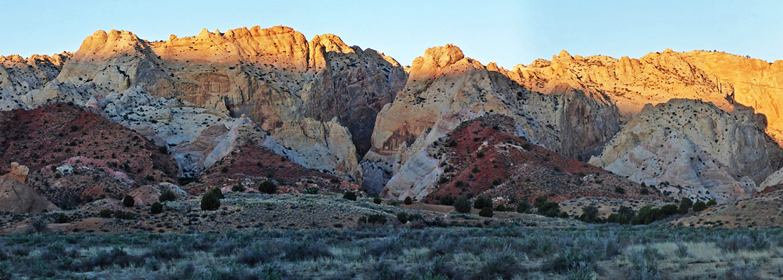
Capitol Reef National Park Trails
Capitol Gorge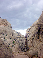 Length 1 miles (1.6 km) Elevation change level Trailhead End of a gravel track at the south end of the scenic drive Rating (1-5) ★★★★★ A dozen or more narrow canyons cut through the Waterpocket Fold. Capitol Gorge is the easiest to explore - starting from the southern end of the park scenic drive, a level track winds through the tall sandstone rocks, reaching the far side after about a mile, and also passing a collection of historic pioneer signatures. A 0.2 mile side trail leads to The Tanks, a collection of eroded crevices that collect rainwater. The Capitol Gorge track was for many years the main route through Capitol Reef, until UT 24 was constructed in 1962. |
Cassidy Arch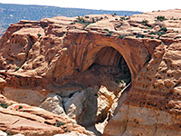 Length 1.75 miles (2.8 km) Elevation change 600 feet (183 meters) Trailhead End of the track to Grand Wash Rating (1-5) ★★★★★ The short, moderately steep trail an overlook of Cassidy Arch starts from the end of the track leading to Grand Wash, climbing the Wingate and Kayenta sandstone cliffs then heading back west to the arch. Continuation hikes are possible along the Frying Pan Trail which branches off to the north, over the top of Capitol Reef. The arch is named after Butch Cassidy, who once camped in Grand Wash. |
Chimney Rock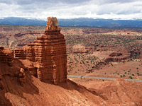 Length 3.5 miles (5.6 km) (loop) Elevation change 580 feet (177 meters) Trailhead Parking area along UT 24 Rating (1-5) ★★★★★ Beginning near milepost 76 of UT 24, this hike climbs quite steeply up the hills that line the north side of the highway, then loops around the top of Mummy Cliff while passing close to Chimney Rock, a solitary pillar of Moenkopi sandstone. This trail is also used to reach Spring Canyon and then Chimney Rock Canyon, which can be followed for many miles either east or west. |
Cohab Canyon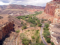 Length 1.5 miles (2.4 km) Elevation change 340 feet (104 meters) Trailhead 1.2 miles along the scenic drive; also reachable along UT 24 Rating (1-5) ★★★★★ Cohab is a short, secluded canyon on the west side of Capitol Reef just south of Fruita on UT 24. The trail to it begins from the national park campground, ascends the cliffs, follows the canyon to the upper end, then descends towards the Fremont River. Junctions lead to two viewpoints of the river, and to Cassidy Arch/Grand Wash (via the Frying Pan Trail). |
| Capitol Reef Tours |
Fremont Gorge Overlook Trail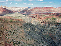 Length 2 miles (3.2 km) Elevation change 1040 feet (317 meters) Trailhead Beside the old blacksmith's shop, along the scenic drive Rating (1-5) ★★★★★ The deepest part of the Fremont River canyon is south of UT 24 and west of the reef, where for several miles the canyon walls exceed 1,000 feet in height. The Fremont Gorge Overlook is the more strenuous of two routes to viewpoints of the canyon, starting near Fruita and ending at the edge of a cliff high above the river. The path also has good views of the multicolored cliffs of Capitol Reef. |
|
Fremont River Length 1.25 miles (2 km) Elevation change 460 feet (140 meters) Trailhead West side of the campground Rating (1-5) ★★★★★ This short nature trail follows the Fremont River, beginning at the campground, through level ground with orchards and fields, then climbs quite sharply to an overlook of the western river canyon. |
Frying Pan Length 3 miles (4.8 km) Elevation change 800 feet (244 meters) Trailhead Pull-out along UT 24, from where the trail starts 0.5 miles west Rating (1-5) ★★★★★ The Frying Pan trail connects the paths to Cohab Canyon and Cassidy Arch, following near the top of Capitol Reef and involving various climbs and descents over slickrock terraces & ravines. |
Golden Throne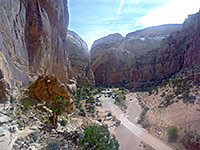 Length 1.8 miles (2.9 km) Elevation change 700 feet (213 meters) Trailhead End of a gravel track at the south end of the scenic drive Rating (1-5) ★★★★★ One of two hikes beginning at the far end of the park scenic drive, this climbs the cliffs on the north side of Capitol Gorge, winding around several side ravines to the top of a dome overlooking the gorge to the south and Golden Throne to the north - a rounded summit nearly 1,000 feet higher. |
Headquarters Canyon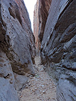 Length 3.6 miles (5.8 km) round trip, to both forks Elevation change 250 feet (76 meters) Trailhead Parking area along Notom-Bullfrog Road, 35 miles south of Hwy 24 Rating (1-5) ★★★★★ Short but deep drainage on the east side of Capitol Reef, with two forks; both form brief sections of narrows, through generally dull-colored sandstone; the Navajo sandstone hereabouts is generally dark and drab in appearance, and the canyons do not receive much sunlight, so the passages are rather gloomy. |
Hickman Bridge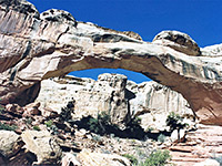 Length 1.2 miles (1.9 km) Elevation change 400 feet (122 meters) Trailhead Parking area beside UT 24 Rating (1-5) ★★★★★ Sandstone arches are found all over Capitol Reef though most are quite inaccessible. Hickman Bridge is one of the few reached by a maintained trail; this starts from UT 24 next to the Fremont River and climbs fairly gradually, along a dry wash to the base of the 130 foot span. |
|
Old Wagon Length 3.5 miles (5.6 km) (loop) Elevation change 1100 feet (335 meters) Trailhead Towards the south end of the scenic drive Rating (1-5) ★★★★★ The Old Wagon Trail is part of a route once used by pioneers to travel between Capitol Gorge and Grover, on the slopes of Miners Mountain. The hike climbs into wooded hills offering increasingly good views of Capitol Reef and the Waterpocket Fold. |
Red Canyon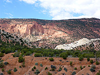 Length 2.7 miles (4.3 km) Elevation change 400 feet (122 meters) Trailhead Far side of Cedar Mesa Campground, along Notom-Bullfrog Road, 21 miles south of Hwy 24 Rating (1-5) ★★★★★ Relatively short canyon on the east side of the Waterpocket Fold which emerges from a wide basin lined by red cliffs, reached by a trail that crosses open land to the mouth of the ravine, then follows the streambed. The hike is not signposted from the access road so is mostly done by people staying at the nearby campground, which has about half a dozen sites, and there is no charge to stay. |
Rim Overlook/ Navajo Knobs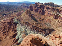 Length 2.4 miles (3.9 km) to Rim Overlook; 4.9 miles (7.9 km) to Navajo Knobs Elevation change 1050 feet (320 meters); 1600 feet (488 meters) Trailhead Parking area beside UT 24 Rating (1-5) ★★★★★ From the trailhead beside UT 24 (also used to reach Hickman Bridge), the longest maintained trail in the park ascends the hillside above the Fremont River and follows the gorge westwards, reaching a viewpoint on the cliff edge 1,000 feet above Fruita after 2.25 miles. From here the path turns away north, across more high ground to a region of eroded Navajo sandstone and another panoramic overlook of the Fremont River valley. |
Spring Canyon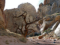 Length 4 miles (6.4 km) or more Elevation change 250 feet (76 meters) Trailhead Parking area along Hwy 24 Rating (1-5) ★★★★★ Long, deep, twisting ravine that joins the north side of the Fremont River in the middle of Capitol Reef. A hike along the lowest few miles encounters tall cliffs, alcoves, pools and a seasonal stream. Some sections of streambed border sandbanks that support trees and bushes, while in places the seasonal water covers most of the canyon floor. |
Sulphur Creek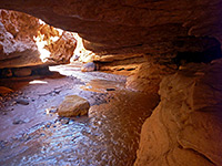 Length 5.3 miles (8.5 km) Elevation change 500 feet (152 meters) Trailhead Parking area for Chimney Rock, along UT 24 Rating (1-5) ★★★★★ Although there is no trail through the deep, watery narrows of Sulphur Creek, the route is well enough known to have an NPS sign at the trailhead, shared with Chimney Rock. The creek emerges beside UT 24 again next to the visitor center, from where the return journey is back along the road, by walking, using a car shuttle or hitching a lift. |
Sunset Point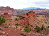 Length 0.4 miles (0.6 km) Elevation change level Trailhead End of a side track, south of UT 24 Rating (1-5) ★★★★★ This short route follows close to the eastern rim of the canyon of Sulphur Creek, to a small summit with 360 degree views of cliffs and peaks, a good place for photographing the sunset. Another even shorter path starting from the same point (end of a side road off UT 24, near the western park entrance) leads to an overlook of the Goosenecks of Sulphur Creek. |
Surprise Canyon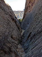 Length 3.9 miles (6.3 km) round trip, for all forks Elevation change 300 feet (91 meters) Trailhead Parking area along Notom-Bullfrog Road, 34.3 miles south of Hwy 24 Rating (1-5) ★★★★★ Short drainage on the east side of the Waterpocket Fold, with three forks, all similar in appearance; briefly narrow then gaining height, enclosed by smooth, vertical cliffs of light-colored Navajo sandstone. The rocks at the edge of the reef are colorful, a mix of white, red and orange, and are eroded into little peaks and ridges, and while the tall cliffs around the narrows are rather gloomy - grey or dull red, the hike offers an easy way to see three moderately interesting canyons in close proximity. |
All Contents © Copyright The American Southwest | Comments and Questions | Contribute | Affiliate Marketing Disclosure | Site Map