Puerto Blanco Drive, Organ Pipe Cactus National Monument
Arizona > Organ Pipe Cactus National Monument > Puerto Blanco Drive
Puerto Blanco Drive
Spectacular, unpaved loop drive through mountains and desert flats on the west side of the national monument, past old mines, springs, historic sites and an oasis. Most is one way, from north to south
Length: 37 miles
Season: All year
Start Point: Hwy 85, near the visitor center
Season: All year
Start Point: Hwy 85, near the visitor center

In 2006, the north section of the Puerto Blanco Drive (beyond mile 5; Pinkley Peak, site of a new picnic area) was closed to the public, just past the turn off to Red Tanks Tinaja. This was due to concerns about drug trafficking and illegal cross-border immigration. The road was reopened in 2014, but the surface has deteriorated, and some parts of the drive require a 4WD vehicle.
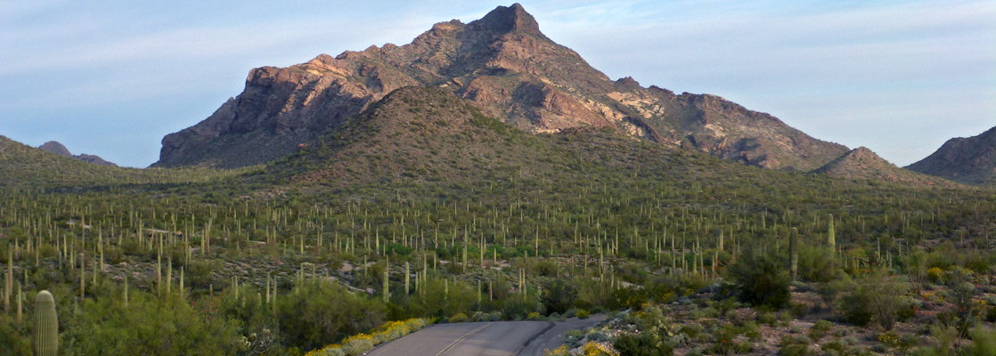
Undoubtedly one of the most scenic roads in Arizona, the 37 mile Puerto Blanco Drive travels deep into the unspoilt backcountry of the Organ Pipe Cactus National Monument, across cactus plains and through mountain foothills. Besides the varied plants of the Sonoran Desert, the drive passes close to old mines, springs, historic sites and a tree-lined oasis, and gives access to several hiking paths ranging from short nature trails to lengthy unmaintained routes.
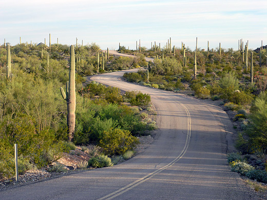
Originally, half the drive was one-way, from the main visitor center on AZ 85 through the Puerto Blanco Mountains to Growler Junction, where it meets a 4WD track that gives crosses the northwest section of the national monument. From here, the road became two-way - south to the Mexican border then right alongside the international boundary fence for 13 miles back to AZ 85 and the village of Lukeville. There is plenty to see on this section but the full journey is even better, and takes around 4 hours, depending on the number of stops. Since 2006, the accessible section of the road (the first 5 miles) has been improved and widened, and is now a two-way route.
Map of the national monument.
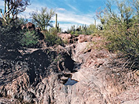
From the visitor center, the Puerto Blanco Drive starts out north, past an interpretive pullout (start point for an off-trail hike to the Twin Peaks), then curves west, around the edge of another part of the Puerto Blanco Mountain range and very soon offers a sense of peace and isolation. After 4 miles a short trail leads to Red Tanks Tinaja, a section of streamway where seasonal floodwaters have carved several potholes ("tinajas") in the underlying red sandstone rock, which hold water for some time after rainfall and so are important for the local wildlife. A round trip to the tanks takes about half an hour and also passes an old well plus many cacti, although no organ pipes. Continuation trails lead to other sites including Senita Basin and Baker Mine. One mile after the trailhead, the road reaches the Pinkley Peak picnic area, where a gate marks the end of the two-way section of the route; beyond, the road is rougher and less traveled. The summit of the nearby peak - the highest point in the Puerto Blanco Mountains - may be reached by a 1.3 mile, off-trail hike.
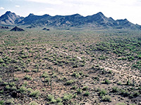
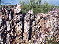
Over the next 6 miles, the road veers north, across the end of the Valley of the Ajo - a great broad depression with evenly-spaced saguaro stretching to the horizon. A small hill at mile 10 offers particularly fine views over the valley, the mountains and the road itself - a perfect wilderness scene. After here the track becomes a little more steep and uneven, bending sharply to the left then back right as it crosses the edge of the Puerto Blanco Mountains. Two long disused mines are located on the rocky slopes - Dripping Springs Mine (reached by a 2 mile trail) and Golden Bell Mine right next to the road. This has two shafts close to an outcrop of colorful mineralised rock, and is now the site of one of several picnic areas along the drive.
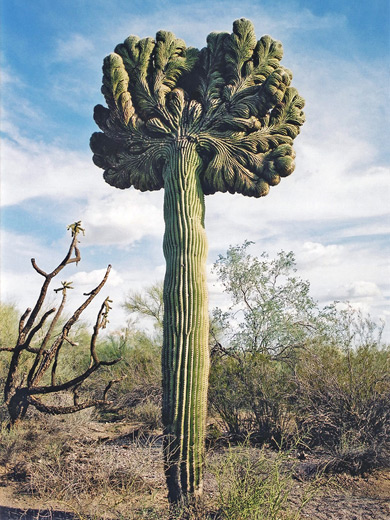
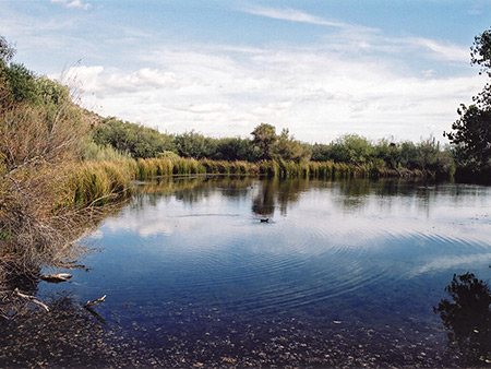
After the mountains the land drops down gradually and organ pipe cacti begin to appear below 1,400 feet, from near the Golden Bell Mine (at mile 17); these plants are not frost tolerant and occur only at low elevations. As the road heads further south, the next two points of interest are Bonita Well - site of a water tower and corral used in cattle ranching operations in the 1930s, and a short trail leading to a cristate saguaro - a rare and beautiful abnormality that is occasionally found when the growing tip of the cactus becomes elongated, forming a convoluted arc. The cactus is reported to have recently died. The drive meets the unpaved road at Growler Junction and becomes 2-way, turning due south to the border with Mexico and another junction - a 0.4 mile side road ends at Quitobaquito Oasis, an odd sight in this otherwise arid land, where several springs feed a large pond surrounded by trees and frequented by ducks and other wildlife.
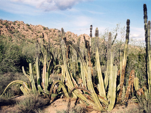
The remaining 13 miles of the Puerto Blanco Drive are mostly quite straight, running next to the small fence that separates the USA from Mexico. At the far side, State Route 2 is a busy four-lane highway with several clusters of houses and shops, quite a contrast to the empty lands before. There are a few places with open gates in the fence where it is possible to drive through onto the main road [these may well now have been closed]. The drive passes some groups of the third and rarest of the large American cacti species - the senita; these are even more susceptible to frost damage than the organ pipes and so generally occur only at the lowest, most southerly part of the national monument, although they are also found in one other area, at Senita Basin. This is a sheltered location at the south edge of the Puerto Blanco Mountains, reached by a 4 mile spur road. As well as being the best place to see the three large species of cacti growing together, there are several hiking trails that climb into the mountains towards other old mines.
Undoubtedly one of the most scenic roads in Arizona, the 37 mile Puerto Blanco Drive travels deep into the unspoilt backcountry of the Organ Pipe Cactus National Monument, across cactus plains and through mountain foothills. Besides the varied plants of the Sonoran Desert, the drive passes close to old mines, springs, historic sites and a tree-lined oasis, and gives access to several hiking paths ranging from short nature trails to lengthy unmaintained routes.
Originally, half the drive was one-way, from the main visitor center on AZ 85 through the Puerto Blanco Mountains to Growler Junction, where it meets a 4WD track that gives crosses the northwest section of the national monument. From here, the road became two-way - south to the Mexican border then right alongside the international boundary fence for 13 miles back to AZ 85 and the village of Lukeville. There is plenty to see on this section but the full journey is even better, and takes around 4 hours, depending on the number of stops. Since 2006, the accessible section of the road (the first 5 miles) has been improved and widened, and is now a two-way route.
Road Map
Map of the national monument.
Red Tanks Tinaja
From the visitor center, the Puerto Blanco Drive starts out north, past an interpretive pullout (start point for an off-trail hike to the Twin Peaks), then curves west, around the edge of another part of the Puerto Blanco Mountain range and very soon offers a sense of peace and isolation. After 4 miles a short trail leads to Red Tanks Tinaja, a section of streamway where seasonal floodwaters have carved several potholes ("tinajas") in the underlying red sandstone rock, which hold water for some time after rainfall and so are important for the local wildlife. A round trip to the tanks takes about half an hour and also passes an old well plus many cacti, although no organ pipes. Continuation trails lead to other sites including Senita Basin and Baker Mine. One mile after the trailhead, the road reaches the Pinkley Peak picnic area, where a gate marks the end of the two-way section of the route; beyond, the road is rougher and less traveled. The summit of the nearby peak - the highest point in the Puerto Blanco Mountains - may be reached by a 1.3 mile, off-trail hike.
Old Mines
Over the next 6 miles, the road veers north, across the end of the Valley of the Ajo - a great broad depression with evenly-spaced saguaro stretching to the horizon. A small hill at mile 10 offers particularly fine views over the valley, the mountains and the road itself - a perfect wilderness scene. After here the track becomes a little more steep and uneven, bending sharply to the left then back right as it crosses the edge of the Puerto Blanco Mountains. Two long disused mines are located on the rocky slopes - Dripping Springs Mine (reached by a 2 mile trail) and Golden Bell Mine right next to the road. This has two shafts close to an outcrop of colorful mineralised rock, and is now the site of one of several picnic areas along the drive.
A Well and an Oasis
After the mountains the land drops down gradually and organ pipe cacti begin to appear below 1,400 feet, from near the Golden Bell Mine (at mile 17); these plants are not frost tolerant and occur only at low elevations. As the road heads further south, the next two points of interest are Bonita Well - site of a water tower and corral used in cattle ranching operations in the 1930s, and a short trail leading to a cristate saguaro - a rare and beautiful abnormality that is occasionally found when the growing tip of the cactus becomes elongated, forming a convoluted arc. The cactus is reported to have recently died. The drive meets the unpaved road at Growler Junction and becomes 2-way, turning due south to the border with Mexico and another junction - a 0.4 mile side road ends at Quitobaquito Oasis, an odd sight in this otherwise arid land, where several springs feed a large pond surrounded by trees and frequented by ducks and other wildlife.
Senita Cacti
The remaining 13 miles of the Puerto Blanco Drive are mostly quite straight, running next to the small fence that separates the USA from Mexico. At the far side, State Route 2 is a busy four-lane highway with several clusters of houses and shops, quite a contrast to the empty lands before. There are a few places with open gates in the fence where it is possible to drive through onto the main road [these may well now have been closed]. The drive passes some groups of the third and rarest of the large American cacti species - the senita; these are even more susceptible to frost damage than the organ pipes and so generally occur only at the lowest, most southerly part of the national monument, although they are also found in one other area, at Senita Basin. This is a sheltered location at the south edge of the Puerto Blanco Mountains, reached by a 4 mile spur road. As well as being the best place to see the three large species of cacti growing together, there are several hiking trails that climb into the mountains towards other old mines.
I drove this road in late November, when the temperature was around 70°F, and the day was both windless and cloudless, unlike other parts of the state; even Phoenix was rather cold and drizzly. No other vehicle passed in the three hours I spent exploring and because of this, and the perfection of the desert scenery, the trip to the Puerto Blanco Drive has to be one of the best days of all the many hundreds I have spent in the Southwest.
All Contents © Copyright The American Southwest | Comments and Questions | Contribute | Affiliate Marketing Disclosure | Site Map