
Highlights:
Artificial lake in the low hills north of Phoenix surrounded by fine Sonoran Desert scenery with abundant wildlife and cacti. The reservoir is popular for camping, boating, swimming and fishing
Nearby town:
Scottsdale, 30 miles
Management:
USFS
Location:
Seasons:
All year. The hot summer weather restricts activities to those on or around the water
Rating (1-5):
★★★★★

Barlett Reservoir is part of the Arizona Deserts itinerary
Bartlett is a medium-sized artificial lake in the mountains of the Tonto National Forest northeast of Phoenix, surrounded by particularly fine Sonoran Desert scenery, and being quite far from the city it does not receive as many visitors so has less litter than other lakes with easier access.
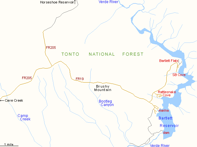
The only approach by road is from the west, starting from the dispersed communities of Cave Creek and Carefree, which seem to be nice places to live - they have many adobe houses blending with an photogenic landscape of large granite boulders and abundant desert plants, especially the ever-present saguaro. More expensive homes are built higher up the hilly ground to the north, and these have great views over the desert towards Phoenix.
The scenery is similar along the 13 mile road to the lake except there are no houses once past the Tonto National Forest boundary, just countless more cacti, bushes and boulders. These gradually give way to grassy plains as the road climbs to a plateau at 3,200 feet, where a side road forks off north, leading to the more remote Horseshoe Lake, then from the junction it is 9 more miles downhill to Bartlett Reservoir, where the grasslands are replaced once more by cacti as the road descends over 1,000 feet.
The lake, or reservoir, was created in 1939 after construction of Bartlett Dam across the Verde River, backing up the waters around 8 miles upstream. The place is named after William H. Bartlett, surveyor and engineer, who first identified the dam site, and continued to work in the Phoenix area until he died, in 1966. The lake has no hydroelectric use, instead it serves only as a water storage facility, in addition to its recreational benefits.
The only approach by road is from the west, starting from the dispersed communities of Cave Creek and Carefree, which seem to be nice places to live - they have many adobe houses blending with an photogenic landscape of large granite boulders and abundant desert plants, especially the ever-present saguaro. More expensive homes are built higher up the hilly ground to the north, and these have great views over the desert towards Phoenix.
The scenery is similar along the 13 mile road to the lake except there are no houses once past the Tonto National Forest boundary, just countless more cacti, bushes and boulders. These gradually give way to grassy plains as the road climbs to a plateau at 3,200 feet, where a side road forks off north, leading to the more remote Horseshoe Lake, then from the junction it is 9 more miles downhill to Bartlett Reservoir, where the grasslands are replaced once more by cacti as the road descends over 1,000 feet.

The lake, or reservoir, was created in 1939 after construction of Bartlett Dam across the Verde River, backing up the waters around 8 miles upstream. The place is named after William H. Bartlett, surveyor and engineer, who first identified the dam site, and continued to work in the Phoenix area until he died, in 1966. The lake has no hydroelectric use, instead it serves only as a water storage facility, in addition to its recreational benefits.
Bartlett Reservoir Table of Contents


Photographs
29 views of Bartlett Reservoir.
The Reservoir
After a self-pay fee station the road forks, two branches following the shoreline north and south, passing various sites for picnics, boat launching and camping. For day use, the best area is Rattlesnake Cove - this has shaded tables, fire rings and showers above a wide, clean, sandy beach. A short walk in either direction along the waters edge leads to quiet, private coves with nice rock formations including many dikes (vertical igneous intrusions cutting through overlying strata) and saguaro right next to the water. Further north is the main camping area, Bartlett Flats, where the road splits into a number of sandy tracks that end at sites on beaches, right next to the water. Generally, access to other parts of the lakeshore is limited; other rougher tracks continue into the mountains but the south part and all of the eastern shore is mostly inaccessible. A good location for primitive camping is along several side tracks on the south side of the approach road, in a semi-riparian area alongside Camp Creek - there are many potential sites here, set amid sandy ground, though quite densely covered by several types of thorny bushes. The surroundings also have many cacti including scattered saguaro and, across the nearby slopes, clumps of the same monzonite boulders as are found in Joshua Tree National Park, plus views of far away hills all around with the north Scottsdale suburbs visible in the distance.


Wildlife
Of all the desert recreation sites around Phoenix, the ground around Bartlett Reservoir seems to have the most abundant wildlife. Walking around the lake, almost every step disturbs one or more lizards of various species, including perhaps the large, secretive chuckwalla, which is often spotted, while Rattlesnake Cove is indeed a favored location for the venomous snake, in particular the western diamondback. The lake contains abundant fish, including small- and large-mouth bass, green sunfish, bluegill, carp and flathead catfish; it is a popular angling location.
Bartlett Reservoir - Nearby Places
- Jewel of the Creek Preserve (25 miles) - a perennial stream in the desert
- Lake Pleasant (50 miles) - popular lake in the Sonoran Desert near Phoenix
Bartlett Reservoir - Similar Places
- Alamo Lake - even more remote reservoir in west central Arizona
- San Carlos Lake - tranquil lake on the Apache Indian Reservation
All Contents © Copyright The American Southwest | Comments and Questions | Contribute | Affiliate Marketing Disclosure | Site Map