Sneffels Highline Trail
Excellent loop trail visiting two Alpine basins high above Telluride, including 5 miles above the treeline; ever-changing views of forests, wildflowers, meadows, streams, ridges and summits
Length: 14 miles (loop), including half a mile each way to reach the trailhead
Elevation change: 3,500 feet
Difficulty: Strenuous
Type: Loop
Usage: Low
Season: Summer and fall
Trailhead: North end of Aspen Street in Telluride, though vehicles have to be left half a mile away at a public lot along Tomboy Drive
Rating (1-5): ★★★★★
Elevation change: 3,500 feet
Difficulty: Strenuous
Type: Loop
Usage: Low
Season: Summer and fall
Trailhead: North end of Aspen Street in Telluride, though vehicles have to be left half a mile away at a public lot along Tomboy Drive
Rating (1-5): ★★★★★

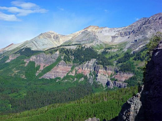
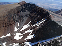
The 13 mile (loop) Sneffels Highline Trail is generally considered to be the top day hike near Telluride, in the western San Juan Mountains, and one of the best anywhere in the whole range. It encounters no lakes but does pass most other types of mountain scenery including pine woods, aspen forest, streams, waterfalls, floral meadows, Alpine basins and a pass above a narrow rocky ridge at 12,260 feet, the high point of the path. The route is named after 14,150 foot Mount Sneffels, a few miles north, and while not coming anywhere near the summit, it does run beneath a dramatic east-west line of cliffs connecting two other peaks (Dallas and Gilpin), eroded into jagged pinnacles and formed of the multicolored, mineralized volcanic rocks typical of the San Juans.
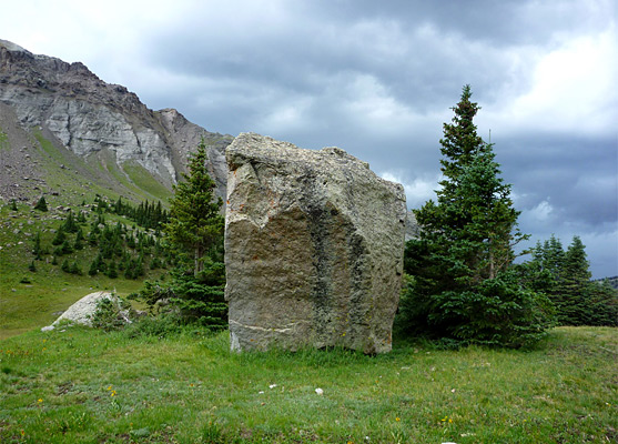
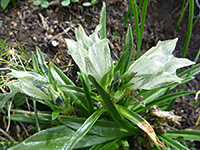
The first and last few miles are mostly through thick forest, but changing aspects and surroundings make these parts of the hike not too monotonous; the highlight though is definitely the middle third (5 miles), all above the treeline. Many dozens of wildflower species grow on the mountainsides, the majority in the high basins but also a good selection lower down.
The route is snow-free for about half the year, though the mountains are subject to intense afternoon thunderstorms in summer so the hike is best started early in the morning, thus ensuring that the cover of the forest is regained in time to avoid the lightning. Counter-clockwise is the recommended direction, since although the initial ascent is steeper, the high point is achieved earlier in the hike.
San Juan Mountains area map, Sneffels Highline topographic map.
46 views along the Sneffels Highline Trail. Wildflower photographs.
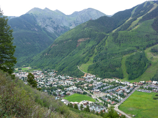
The unmarked Sneffels Highline trailhead is located at the north end of Aspen Street in Telluride, but there are no parking spaces here. Some nearby residential roads allow two hour parking which is not nearly enough for the hike, so visitors have to leave cars at one of two public lots on the southwest edge of town, beside the San Miguel River; one at the end of Tomboy Drive (the 'Carhenge' lot), the other along Mahoney Drive, 0.6 and 0.8 miles respectively from the trailhead. Aspen Street ends in a short gravel track leading to a gate and an information board with map, in shady forest beside Cornet Creek. Two footpaths start here; one climbs northeastwards, following the creek past a waterfall to several old mines and then over a high ridge into Governor Basin, while the other (signed the Jed Wiebe Trail) heads west, towards the start of the Sneffels Highline loop.
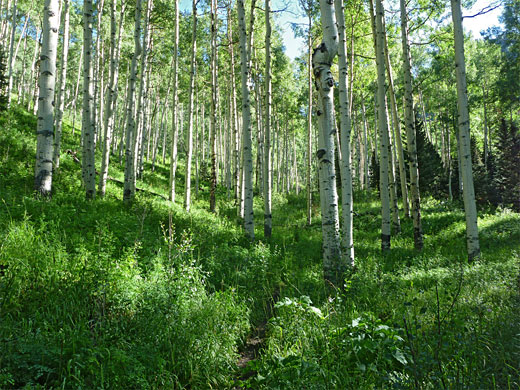
This path is straight at first, ascending quite steeply up the hillside, and soon gives good views of Telluride below. It bends back east after a while, moving into thicker woodland and turns again, now passing aspen trees, up to a junction in an open area close to Butcher Creek, where the Jed Wiebe Trail turns away to the east, later linking with the Governor Basin route to form a 3 mile loop. Continuing west, the main path crosses Butcher Creek and reaches a second intersection at the start of the Sneffels Highline Trail, which is much narrower, marked as a wilderness route, so no cycles or horses are allowed. The path winds across a patch of long grass and enters the woods, at the start of a lengthy climb up Butcher Creek valley, initially all through aspen, later with pines close by, on the moister east side of the ravine. The path comes close to the creek at one point after gaining several hundred feet, climbing a thin, treeless, grassy corridor, then curves away, temporarily out of the trees to a promontory with views of a rocky summit ahead and the lower end of the Telluride box canyon to the south, already 1,500 feet below.
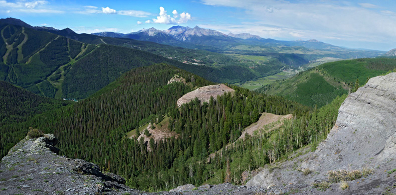
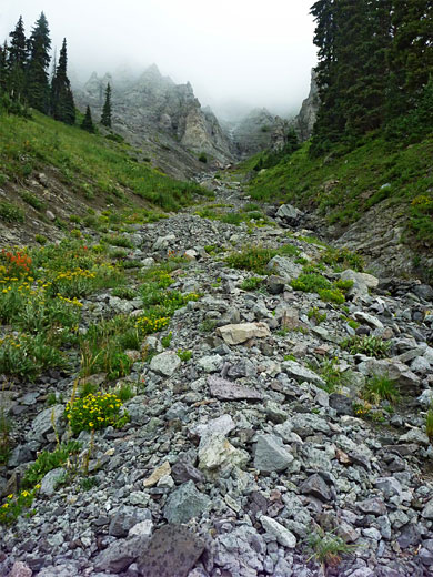
The terrain becomes predominantly wooded again, though mixed with sunny clearings that allow gradually more extensive views southwards, until a gap in a line of low cliffs to the east gives the first glimpse of the higher mountains ahead, rising above the north side of Mill Creek Basin. The trail continues climbing through pine woods and grassy patches, staying east of the ridgeline for a while before crossing to the west side, where a rock-lined valley can be seen below, holding an forceful stream that originates from Pack Basin not far ahead. The surroundings are still generally shaded but an increasing number of wildflowers are found alongside the path including bluebells, larkspur, ragwort, clover, arnica and various species of daisy. The stream comes quite close, until the trail moves away uphill, crossing wooded slopes split by several boulder-filled streamways, conduits for the heavy rainfall that often affects this region.
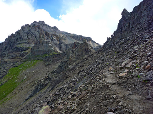
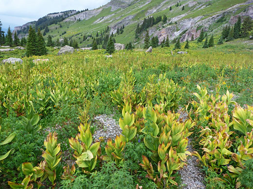
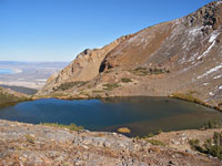
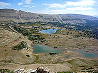
The path swings back towards the creek and leaves the forest completely, entering the upper end of the valley (Pack Basin), now mostly dry but home to many more wildflowers. The gradient gradually increases, especially so once a set of switchbacks begin, taking the trail up the north side of the basin to a pass in a narrow, rugged ridge extending west from Mount Emma. The ridgeline is much too steep to climb higher at this point but the summit could be reached by hiking off-trail up the slopes on the east side of the basin. Ahead, on the far side of the ridge, is the bigger and even more beautiful valley of Mill Creek Basin, guarded by impassable cliffs on the north side, topped by eroded spires of orange and grey and including two major summits, 13,809 foot Dallas Peak and 13,694 foot Gilpin Peak.
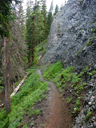
The trail drops down the north side of the ridge, over ground entirely covered by big boulders and loose scree, still sheltering several less common wildflower species such as erigeron leiomerus (rockslide daisy), penstemon harbourii (Harbour's beardtongue), phacelia sericea (purple fringe) and oxyria digyna (mountain sorrel). A few steeply-descending switchbacks give way to a longer straight which leads back to grassy terrain and a small boggy creek, lined by yet more different species of wildflowers. The path crosses other streams of various sizes during a gentle descent along the north side of the basin, as patches of pine woodland return to the south. A sign marks the edge of the Mount Sneffels Wilderness, approximately at the end of the upper section of the valley, beyond which land falls away much more steeply.
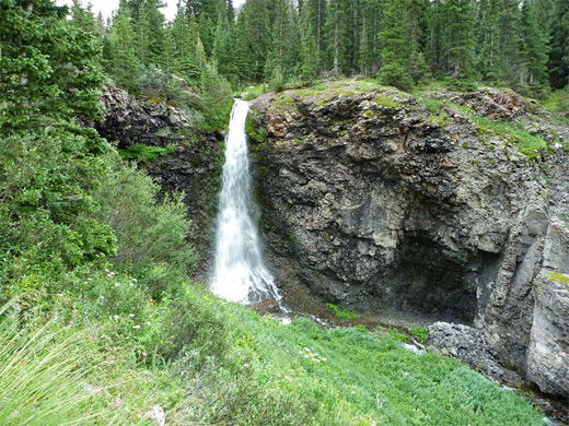
The trail comes within sight of a waterfall, flowing 40 feet over a rough, dark grey cliff, then veers away, descending slightly through a field of corn lilies before beginning a long traverse of the hillside, level or climbing slightly. Around a dozen big boulder chutes are passed, the force of the occasional floodwaters evident from the huge rocks left lying in the streamway. Eventually clumps of trees appear ahead and the surroundings gradually become more overgrown. The trail climbs a little, rounds a corner into a patch of thicker woodland, then passes an aspen grove and a rocky promontory, followed by a steep descent; switchbacking down through the aspen, past another wilderness sign, along an open ridge and back into pine forest. The ridge continues, now less steep, to a junction, where the Deep Creek Trail heads west whilst the Sneffels loop turns east and has a steep ascent through pines to a more gradually sloping, less wooded hillside above Mill Creek.
The next section is steep once more, narrow and slippery when wet, descending via switchbacks all the way to the creek, where it meets a forest track (Mill Creek Road). A left fork is signed to the Jed Wiebe Trail, and this crosses the creek on a bridge and soon passes the ruins of a wooden pumping shed, from where a rusty pipe leads across the hillside, following the trail as it traverses southwards, staying level at about 9,700 feet. It rounds a sharp corner, where Telluride comes into view again, and continues level, now heading east for another 3/4 mile before curving towards the Butcher Creek drainage, back to the junction at the start of the Sneffels Highline loop.
The first and last few miles are mostly through thick forest, but changing aspects and surroundings make these parts of the hike not too monotonous; the highlight though is definitely the middle third (5 miles), all above the treeline. Many dozens of wildflower species grow on the mountainsides, the majority in the high basins but also a good selection lower down.
The route is snow-free for about half the year, though the mountains are subject to intense afternoon thunderstorms in summer so the hike is best started early in the morning, thus ensuring that the cover of the forest is regained in time to avoid the lightning. Counter-clockwise is the recommended direction, since although the initial ascent is steeper, the high point is achieved earlier in the hike.
Location
San Juan Mountains area map, Sneffels Highline topographic map.
Photographs
46 views along the Sneffels Highline Trail. Wildflower photographs.
Sneffels Highline Trailhead
The unmarked Sneffels Highline trailhead is located at the north end of Aspen Street in Telluride, but there are no parking spaces here. Some nearby residential roads allow two hour parking which is not nearly enough for the hike, so visitors have to leave cars at one of two public lots on the southwest edge of town, beside the San Miguel River; one at the end of Tomboy Drive (the 'Carhenge' lot), the other along Mahoney Drive, 0.6 and 0.8 miles respectively from the trailhead. Aspen Street ends in a short gravel track leading to a gate and an information board with map, in shady forest beside Cornet Creek. Two footpaths start here; one climbs northeastwards, following the creek past a waterfall to several old mines and then over a high ridge into Governor Basin, while the other (signed the Jed Wiebe Trail) heads west, towards the start of the Sneffels Highline loop.
Butcher Creek
This path is straight at first, ascending quite steeply up the hillside, and soon gives good views of Telluride below. It bends back east after a while, moving into thicker woodland and turns again, now passing aspen trees, up to a junction in an open area close to Butcher Creek, where the Jed Wiebe Trail turns away to the east, later linking with the Governor Basin route to form a 3 mile loop. Continuing west, the main path crosses Butcher Creek and reaches a second intersection at the start of the Sneffels Highline Trail, which is much narrower, marked as a wilderness route, so no cycles or horses are allowed. The path winds across a patch of long grass and enters the woods, at the start of a lengthy climb up Butcher Creek valley, initially all through aspen, later with pines close by, on the moister east side of the ravine. The path comes close to the creek at one point after gaining several hundred feet, climbing a thin, treeless, grassy corridor, then curves away, temporarily out of the trees to a promontory with views of a rocky summit ahead and the lower end of the Telluride box canyon to the south, already 1,500 feet below.
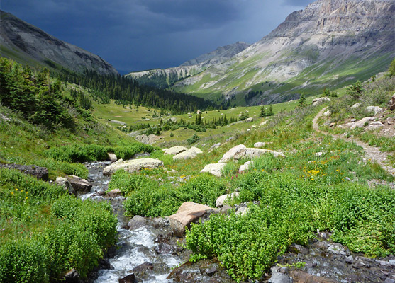
Pack Basin
The terrain becomes predominantly wooded again, though mixed with sunny clearings that allow gradually more extensive views southwards, until a gap in a line of low cliffs to the east gives the first glimpse of the higher mountains ahead, rising above the north side of Mill Creek Basin. The trail continues climbing through pine woods and grassy patches, staying east of the ridgeline for a while before crossing to the west side, where a rock-lined valley can be seen below, holding an forceful stream that originates from Pack Basin not far ahead. The surroundings are still generally shaded but an increasing number of wildflowers are found alongside the path including bluebells, larkspur, ragwort, clover, arnica and various species of daisy. The stream comes quite close, until the trail moves away uphill, crossing wooded slopes split by several boulder-filled streamways, conduits for the heavy rainfall that often affects this region.
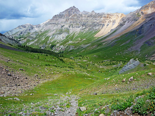
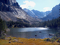
Mill Creek Basin
The path swings back towards the creek and leaves the forest completely, entering the upper end of the valley (Pack Basin), now mostly dry but home to many more wildflowers. The gradient gradually increases, especially so once a set of switchbacks begin, taking the trail up the north side of the basin to a pass in a narrow, rugged ridge extending west from Mount Emma. The ridgeline is much too steep to climb higher at this point but the summit could be reached by hiking off-trail up the slopes on the east side of the basin. Ahead, on the far side of the ridge, is the bigger and even more beautiful valley of Mill Creek Basin, guarded by impassable cliffs on the north side, topped by eroded spires of orange and grey and including two major summits, 13,809 foot Dallas Peak and 13,694 foot Gilpin Peak.
Descent of the Valley
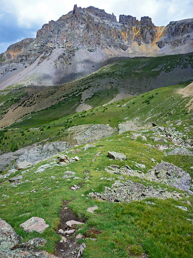
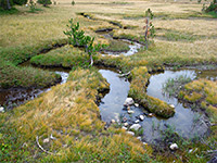
The trail drops down the north side of the ridge, over ground entirely covered by big boulders and loose scree, still sheltering several less common wildflower species such as erigeron leiomerus (rockslide daisy), penstemon harbourii (Harbour's beardtongue), phacelia sericea (purple fringe) and oxyria digyna (mountain sorrel). A few steeply-descending switchbacks give way to a longer straight which leads back to grassy terrain and a small boggy creek, lined by yet more different species of wildflowers. The path crosses other streams of various sizes during a gentle descent along the north side of the basin, as patches of pine woodland return to the south. A sign marks the edge of the Mount Sneffels Wilderness, approximately at the end of the upper section of the valley, beyond which land falls away much more steeply.
Hillside above Mill Creek
The trail comes within sight of a waterfall, flowing 40 feet over a rough, dark grey cliff, then veers away, descending slightly through a field of corn lilies before beginning a long traverse of the hillside, level or climbing slightly. Around a dozen big boulder chutes are passed, the force of the occasional floodwaters evident from the huge rocks left lying in the streamway. Eventually clumps of trees appear ahead and the surroundings gradually become more overgrown. The trail climbs a little, rounds a corner into a patch of thicker woodland, then passes an aspen grove and a rocky promontory, followed by a steep descent; switchbacking down through the aspen, past another wilderness sign, along an open ridge and back into pine forest. The ridge continues, now less steep, to a junction, where the Deep Creek Trail heads west whilst the Sneffels loop turns east and has a steep ascent through pines to a more gradually sloping, less wooded hillside above Mill Creek.
End of the Sneffels Loop
The next section is steep once more, narrow and slippery when wet, descending via switchbacks all the way to the creek, where it meets a forest track (Mill Creek Road). A left fork is signed to the Jed Wiebe Trail, and this crosses the creek on a bridge and soon passes the ruins of a wooden pumping shed, from where a rusty pipe leads across the hillside, following the trail as it traverses southwards, staying level at about 9,700 feet. It rounds a sharp corner, where Telluride comes into view again, and continues level, now heading east for another 3/4 mile before curving towards the Butcher Creek drainage, back to the junction at the start of the Sneffels Highline loop.

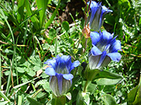
Mt Sneffels Wildflowers
More Sneffels wildflower photographs
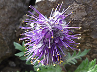 Phacelia sericea |
 Gentiana algida |
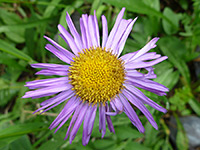 Erigeron eximius |
 Gentiana parryi |
More Sneffels wildflower photographs
Sneffels Highline Trail - Similar Hikes
All Contents © Copyright The American Southwest | Comments and Questions | Contribute | Affiliate Marketing Disclosure | Site Map