Rainbow Gardens, Lake Mead National Recreation Area
Arizona > Lake Mead National Recreation Area > Rainbow Gardens


Rainbow Gardens
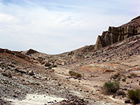
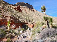
Colorful badlands near the west edge of Lake Mead, below Lava Butte; low mounds split by branched ravines, with scattered wildflowers and cacti. Explored by an easy, off-trail hike
Length: About 1.5 miles
Elevation change: 170 feet
Difficulty: Easy
Type: One way, off-trail
Usage: Low
Season: Fall, winter, spring; summers are generally too hot
Trailhead: Pullout along Northshore Road
Rating (1-5): ★★★★★
Elevation change: 170 feet
Difficulty: Easy
Type: One way, off-trail
Usage: Low
Season: Fall, winter, spring; summers are generally too hot
Trailhead: Pullout along Northshore Road
Rating (1-5): ★★★★★


Rainbow Gardens is an area of pastel-colored badlands and upturned strata near the west end of Lake Mead, south and southwest of the distinctive peak of Lava Butte, a volcanic summit. This region is protected as the Rainbow Gardens Area of Critical Environmental Concern, and the northern section is contained within the proposed East Las Vegas National Monument, which includes additional lands to the north.
The rocks of the gardens are a complex mix of sandstone, siltstone, mudstone, conglomerate, limestone, gypsum, dolostone and basalt; most widespread is the Rainbow Gardens Formation, and this is, as its name suggests, also the most colorful, with strata in shades of grey, yellow, pink and orange, plus white. A similar region, albeit with different bedrock, is Rainbow Canyon, 15 miles east.
The badlands extend for over 4 miles and can be accessed from several starting points including from some of the residential streets of Lake Las Vegas in the south, and from Lake Mead Boulevard in the north, or, for a shorter hike, from Northshore Road, this accessing the southeast corner of the gardens; from here the hiking route follows a minor drainage, Lava Butte Wash, into a typical section of the gardens, below the south face of the butte. The round-trip here is about 3 miles, taking not much more than an hour.
A suitable parking place is a pull-out on the north side of Northshore Road, just east of the crossing of Lava Butte Wash, which is a wide, dry and rather featureless drainage, without any hints of the more colorful lands ahead. An old track leads down from the road to the streambed then fades away; the hike then is right along the streambed for about a mile, veering left at a major fork and continuing towards an area of whitish mounds that mark the edge of the badlands. Not far ahead are more colorful slopes, in shades of pink, grey and green, crossed by shallow, branched ravines that provide walking routes through the mounds. The ground is mostly unvegetated but sprinkled in some places with many specimens of the otherwise uncommon Johnson's pineapple cactus, which produce large pink-purple flowers in spring.

The rocks of the gardens are a complex mix of sandstone, siltstone, mudstone, conglomerate, limestone, gypsum, dolostone and basalt; most widespread is the Rainbow Gardens Formation, and this is, as its name suggests, also the most colorful, with strata in shades of grey, yellow, pink and orange, plus white. A similar region, albeit with different bedrock, is Rainbow Canyon, 15 miles east.
The badlands extend for over 4 miles and can be accessed from several starting points including from some of the residential streets of Lake Las Vegas in the south, and from Lake Mead Boulevard in the north, or, for a shorter hike, from Northshore Road, this accessing the southeast corner of the gardens; from here the hiking route follows a minor drainage, Lava Butte Wash, into a typical section of the gardens, below the south face of the butte. The round-trip here is about 3 miles, taking not much more than an hour.


The Hike
A suitable parking place is a pull-out on the north side of Northshore Road, just east of the crossing of Lava Butte Wash, which is a wide, dry and rather featureless drainage, without any hints of the more colorful lands ahead. An old track leads down from the road to the streambed then fades away; the hike then is right along the streambed for about a mile, veering left at a major fork and continuing towards an area of whitish mounds that mark the edge of the badlands. Not far ahead are more colorful slopes, in shades of pink, grey and green, crossed by shallow, branched ravines that provide walking routes through the mounds. The ground is mostly unvegetated but sprinkled in some places with many specimens of the otherwise uncommon Johnson's pineapple cactus, which produce large pink-purple flowers in spring.


Rainbow Gardens Topographic Map


Rainbow Gardens Wildflowers
 Desert broomrape |
 Johnson's pineapple cactus |
 Flatcrown buckwheat |
 Annual turtleback |