Boulder Creek, Grand Staircase-Escalante National Monument
Utah > Grand Staircase-Escalante National Monument > Boulder Creek
Boulder Creek
Short, cross country hike down a rocky ravine into the middle part of Boulder Creek, which, if water levels are not too high, can then be followed downstream through long stretches of narrows, all the way to the Escalante River
Length: 1.5 miles to the creek, from where the Escalante River is 6 miles away downstream
Elevation change: 400 feet
Difficulty: Easy to moderate; one pothole to pass, by climbing a steep slickrock slope
Type: One way, off trail
Usage: Low
Season: Late spring, summer, fall
Trailhead: Verge beside UT 12
Rating (1-5): ★★★★★
Elevation change: 400 feet
Difficulty: Easy to moderate; one pothole to pass, by climbing a steep slickrock slope
Type: One way, off trail
Usage: Low
Season: Late spring, summer, fall
Trailhead: Verge beside UT 12
Rating (1-5): ★★★★★

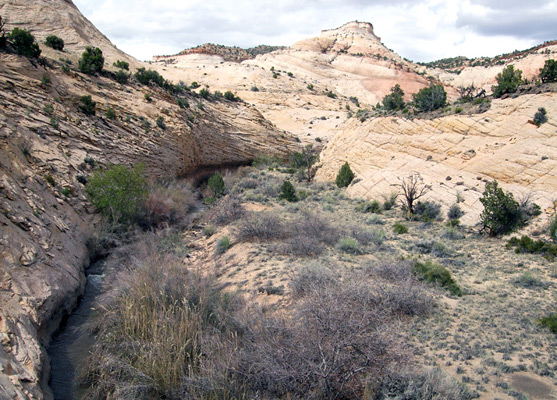
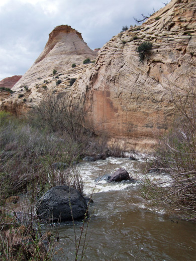
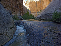
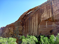
The long drainage of Boulder Creek begins as two forks high up on the Aquarius Plateau, flowing south past the town of Boulder, joining Deer Creek then meeting the Escalante River 5 miles downstream from the UT 12 bridge. The lower section is the most scenic, as for several miles the creek is enclosed by sheer walls of white Navajo sandstone, forming extended narrows sections with deep pools and cascades, though this area is explored less often than other Escalante tributaries nearby, partly because the creek carries a large amount of water during the snowmelt season, restricting hiking to a few months between mid summer and early fall.
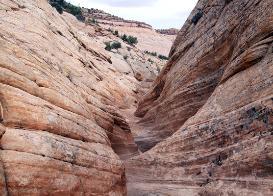
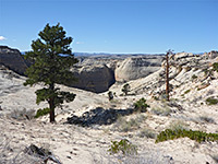
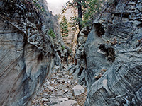
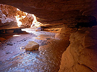
There is no recognized trailhead for Boulder Creek, and while the hike could begin from the UT 12 crossing near Boulder, the next 7 miles or so are not especially interesting since the canyon is relatively wide and shallow. Instead, direct access to the lower section is possible via a short (1.5 mile) cross-country route starting along UT 12 on top of Haymaker Bench, just before the road descends into the adjacent drainage of Calf Creek. Even if Boulder Creek is flowing too fast for easy progress downstream, the hike into the canyon is enjoyable, descending a colorful slickrock ravine, the lower end of which has a few potholes and narrow channels.
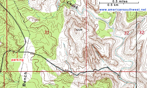
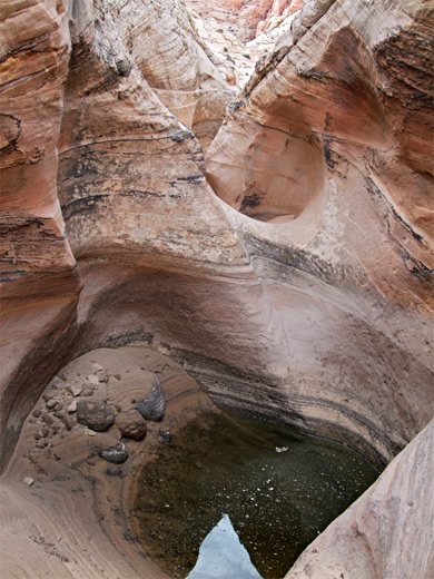
Vehicles may be parked either on a narrow verge on the east side of UT 12 (between miles 76 and 77), near a gate in the adjacent boundary fence, or at a larger pullout a little way south. Powerlines come close to the road at this point, running along the ridgetop of Haymaker Bench, and provide a visible landmark to aim for when returning. The ravine can be seen ahead, and soon the cliffs on the far side of Boulder Creek come into view. The route is across sand dunes and down into the upper end of a shallow wash, which is then followed all the way to the creek. Various other branches join, but the combined streamway remains fairly shallow and open most of the way. The surrounding rocks are light colored, a mix of shades of pink and yellow, and are nicely eroded. The wash descends via a few short drops over faultlines, but otherwise stays fairly level and free of obstructions apart from a narrow place towards the lower end, containing a big pothole. This may be passed by climbing the steep slickrock slope on the left (north); beyond are some more potholes and a shallow, twisting slot, which leads to Boulder Creek, joining it in the middle of a wide section, on the west side of a bend. On the far side is a sandy/bushy area extending for about a quarter of a mile, before the canyon narrows in both directions. In general this part of the creek has a lot of undergrowth, and walking any further may be easier directly along the creek, if water levels are not too high.
There is no recognized trailhead for Boulder Creek, and while the hike could begin from the UT 12 crossing near Boulder, the next 7 miles or so are not especially interesting since the canyon is relatively wide and shallow. Instead, direct access to the lower section is possible via a short (1.5 mile) cross-country route starting along UT 12 on top of Haymaker Bench, just before the road descends into the adjacent drainage of Calf Creek. Even if Boulder Creek is flowing too fast for easy progress downstream, the hike into the canyon is enjoyable, descending a colorful slickrock ravine, the lower end of which has a few potholes and narrow channels.
Route to Boulder Creek
Vehicles may be parked either on a narrow verge on the east side of UT 12 (between miles 76 and 77), near a gate in the adjacent boundary fence, or at a larger pullout a little way south. Powerlines come close to the road at this point, running along the ridgetop of Haymaker Bench, and provide a visible landmark to aim for when returning. The ravine can be seen ahead, and soon the cliffs on the far side of Boulder Creek come into view. The route is across sand dunes and down into the upper end of a shallow wash, which is then followed all the way to the creek. Various other branches join, but the combined streamway remains fairly shallow and open most of the way. The surrounding rocks are light colored, a mix of shades of pink and yellow, and are nicely eroded. The wash descends via a few short drops over faultlines, but otherwise stays fairly level and free of obstructions apart from a narrow place towards the lower end, containing a big pothole. This may be passed by climbing the steep slickrock slope on the left (north); beyond are some more potholes and a shallow, twisting slot, which leads to Boulder Creek, joining it in the middle of a wide section, on the west side of a bend. On the far side is a sandy/bushy area extending for about a quarter of a mile, before the canyon narrows in both directions. In general this part of the creek has a lot of undergrowth, and walking any further may be easier directly along the creek, if water levels are not too high.
Topographic Map
Boulder Creek - Similar Hikes
All Contents © Copyright The American Southwest | Comments and Questions | Contribute | Affiliate Marketing Disclosure | Site Map