West of the state park, Palo Duro Canyon is largely inaccessible as well as being privately owned, though it can be seen again 20 miles downstream, where it is crossed by state highway 207, part of the Texas Plains Trail. This is a 550 mile circular driving route across the high plains that from Palo Duro heads south following the caprock escarpment as far as Gail on US 180 then turns northwest, through Lubbock and due north to Channing, east around the top of Lake Meredith then south through Panhandle and Amarillo. The route to this crossing of Palo Duro Canyon from the state park is down I-27 then east along 285 for 26 miles to the junction with 207. Once a few miles away from the interstate, there are few houses and little traffic, and the countryside is quite empty, just endless grassy fields, not cropped, unlike much of the Panhandle that is often quite busy and farmed more intensively.
All of north Texas has scattered abandoned buildings but here the percentage of those empty seems to be higher. Every few miles there stands an old wooden dwelling with overgrown garden, some with relics of the former owners but others quite empty, all slowly falling apart under the Texas sunshine. But plenty of people do still live out on the prairie, and road 285 passes a variety of dwellings, from pristine modern houses fronted by well cropped lawns to those quite run down, surrounded by old machinery and rusty cars.
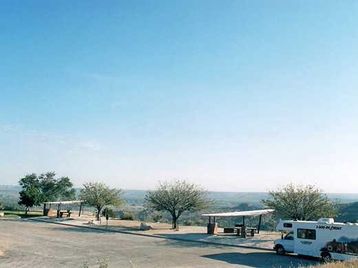
Road 285 passes through one small town (Wayside) and meets 207, where a right turn leads to the larger town of Silverton and on to the Caprock Canyons State Park, which has similar scenery to Palo Duro but is much less visited, while a left turn heads towards the Red River. Just before the descent into Palo Duro Canyon is a nice well kempt rest area, furnished with shelters, benches, tables, bbq stands, and plenty of parking. From here several miles of the canyon are visible, and this makes an excellent (free) place for overnight camping; although right next to the highway, the area is out of sight from it since the road drops steeply down into the valley. Unlike other Southwest states, almost all land in Texas is privately owned so it is harder to find free camping places, even out west where much of the land is quite empty.
The rest area is dedicated to William Henry Hamblin (1876-1952), who lived in nearby Wayside and spent several years pioneering the road down the canyon, which is still the only crossing for 70 miles in either direction. The road was a gravel track at first but was paved a few years after his death and became state route 207.
Other natural attractions of this part of north Texas are few and far between. Ten miles southeast of Canyon is Buffalo Lake National Wildlife Refuge, a small reservoir popular for camping, hiking and wildlife viewing, while north of Amarillo, the much larger Lake Meredith National Recreation Area offers similar activities. But for the most part, the Panhandle has just never ending farmland with big blue skies, long straight roads, corn rolls, water towers, and other hypnotic scenery.
All of north Texas has scattered abandoned buildings but here the percentage of those empty seems to be higher. Every few miles there stands an old wooden dwelling with overgrown garden, some with relics of the former owners but others quite empty, all slowly falling apart under the Texas sunshine. But plenty of people do still live out on the prairie, and road 285 passes a variety of dwellings, from pristine modern houses fronted by well cropped lawns to those quite run down, surrounded by old machinery and rusty cars.
Road 285 passes through one small town (Wayside) and meets 207, where a right turn leads to the larger town of Silverton and on to the Caprock Canyons State Park, which has similar scenery to Palo Duro but is much less visited, while a left turn heads towards the Red River. Just before the descent into Palo Duro Canyon is a nice well kempt rest area, furnished with shelters, benches, tables, bbq stands, and plenty of parking. From here several miles of the canyon are visible, and this makes an excellent (free) place for overnight camping; although right next to the highway, the area is out of sight from it since the road drops steeply down into the valley. Unlike other Southwest states, almost all land in Texas is privately owned so it is harder to find free camping places, even out west where much of the land is quite empty.
The rest area is dedicated to William Henry Hamblin (1876-1952), who lived in nearby Wayside and spent several years pioneering the road down the canyon, which is still the only crossing for 70 miles in either direction. The road was a gravel track at first but was paved a few years after his death and became state route 207.
Other natural attractions of this part of north Texas are few and far between. Ten miles southeast of Canyon is Buffalo Lake National Wildlife Refuge, a small reservoir popular for camping, hiking and wildlife viewing, while north of Amarillo, the much larger Lake Meredith National Recreation Area offers similar activities. But for the most part, the Panhandle has just never ending farmland with big blue skies, long straight roads, corn rolls, water towers, and other hypnotic scenery.
All Contents © Copyright The American Southwest | Comments and Questions | Contribute | Affiliate Marketing Disclosure | Site Map