Smith Fork Canyon
Good narrows in a secluded, rarely visited drainage leading to Lake Powell. Six east-side tributaries also form short slots, some very testing to explore
Length: 5.5 miles to the end of the narrows, ca 7.5 miles to Lake Powell (less 3 miles if driving to the end of the track)
Difficulty: Easy to moderate in the main canyon - several obstructions to climb over
Management: BLM, NPS (Glen Canyon NRA)
Rocks: Navajo sandstone
Season: Spring, summer, fall
Trailhead: Dirt track beside Hansen Creek, or towards the east end of the track
Rating (1-5): ★★★★★
Difficulty: Easy to moderate in the main canyon - several obstructions to climb over
Management: BLM, NPS (Glen Canyon NRA)
Rocks: Navajo sandstone
Season: Spring, summer, fall
Trailhead: Dirt track beside Hansen Creek, or towards the east end of the track
Rating (1-5): ★★★★★

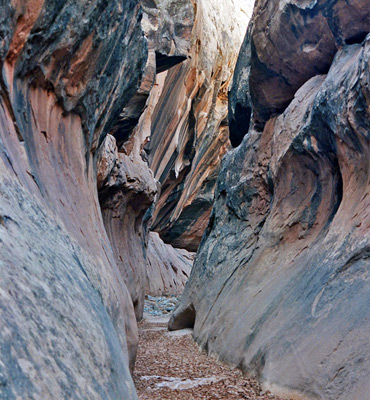
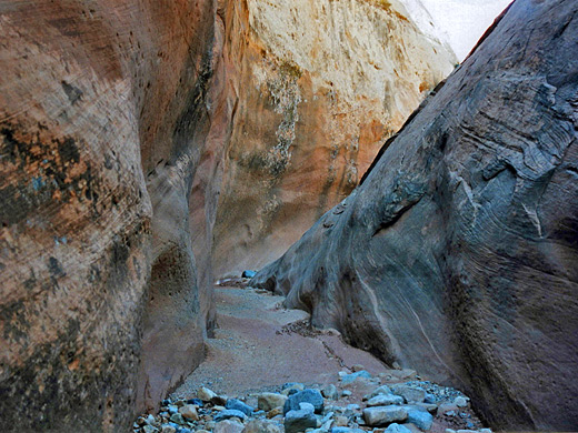
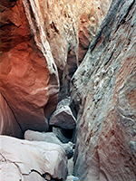
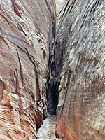
Another classic Lake Powell slot canyon, Smith Fork contains lengthy stretches of pretty narrows including one section that is especially deep and enclosed, plus several extremely tight tributaries. The canyon has a great wilderness setting, lying amidst an open expanse of rolling sandy desert beneath the tall peaks of the Little Rockies near Bullfrog Marina, though the immediate surroundings are slickrock domes and slopes made of the familiar Navajo sandstone. The lower end opens out into a cliff-bound, cottonwood-lined wash and eventually meets the lake, many meters below its original level, after long patches of quicksand, mud and driftwood.
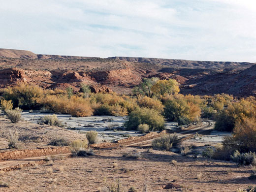
Smith Fork drains the southern slopes of Mount Ellsworth a few miles east of Bullfrog Marina and UT 276, and can be reached either by walking cross country from the highway or, if road conditions allow, by driving along one of several dirt tracks that cross the flat land around the canyon, in particular the first side track on the east after the crossing of Hansen Creek (about 2 miles south), which is 4 miles north of the Glen Canyon NRA boundary. There are plenty of good, free campsites hereabouts, including one a short distance along this track, a little way past a Utah highways depot. The left branch of the track crosses the creek - a point that may stop non-4WD vehicles - then bears east and later northeast towards a promontory called Danish Knoll. Turning right at a T-junction, the canyon is reached in another mile.
17 views of Smith Fork Canyon.
The full length of Smith Fork is around 15 miles though the upper reaches are shallow, and the most interesting part begins below a rockfall 3 miles from the high water mark of Lake Powell. The rockfall marks the point below which entry to Smith Fork, on the west side at least, is made difficult as the walls are generally too high and sheer, so the first objective is to head towards the canyon above the fall, descending perhaps along a small ravine just north of a distinctive rounded Navajo dome (marked 4140T on the topo map). Ahead, stretching away to the north and east lies a large area of more slickrock, crossed by several likely looking slot canyons though these are not very deep.
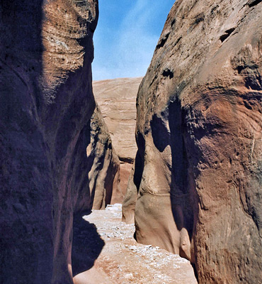
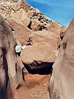
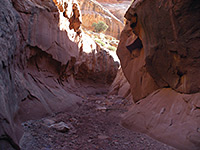
The main canyon is at first only a few meters wide and deep, already mostly vertical sided but not particularly notable until after the rock fall - this is a staged drop over three big boulders. The first two are simple to climb over while the lowest requires a jump of about 6 feet into mud, or maybe a pool, then after this the next easy exit back west is not until below the end of the narrows, quite close to the lake.
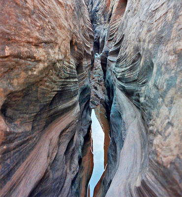
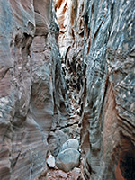
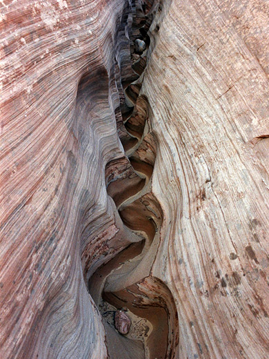
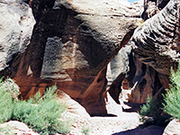
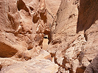
The canyon is now significantly deeper with only occasional routes out, via small tributaries on the east side, and offers mostly easy walking on a flat level floor of sand and small stones, with no vegetation. Occasional chokestones provide minor obstacles. The first east-side tributary is reached quite soon, and has similar forms and textures to Brimstone Gulch or Egypt 3, though shallower - it is just 18 inches wide in places, angled away from vertical, and is formed by dark rocks with knobbly inclusions and thin black bands running parallel to the streamway. It soon forks and opens out at the junction allowing egress to the slickrock above. The left branch begins with a nice small-scale swirling channel then deepens and for some distance forms another very narrow slot, sometimes requiring sideways movement to follow, always quite straight and with a base of pebbles or bare rock that often narrows to a sharp point and may harbor a few pools. A few small troublesome chokestones block the way, and these become more frequent further upstream. This passage remains about the same depth all along and while quite unusual, is not particularly photogenic. The right fork of the side canyon is too narrow to follow properly, is also quite long and a little less deep.
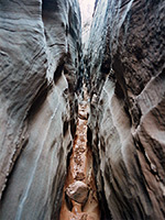
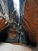
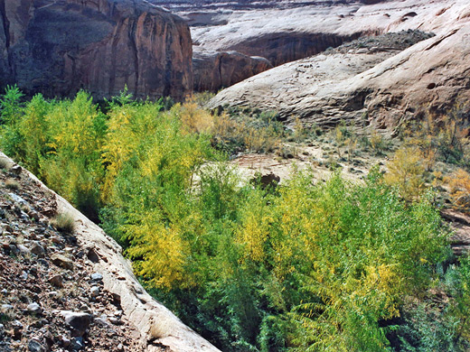
The main canyon continues south and is joined by another very narrow branch on the left, also not negotiable at ground level. Not far beyond the drainage turns west, deepens, and curves round a 180° bend - the best part of the slot, with colorful striated rocks, wavy walls and deep passages. They also have mud and pools, and are quite dark, rarely illuminated by sunlight. This part opens out into a graceful passageway with smooth walls streaked by desert varnish, which soon widens further, enough for sandbanks to form at either side while trees, reeds and grass start growing, all nourished by a small stream that begins to flow, and also creates patches of quicksand.
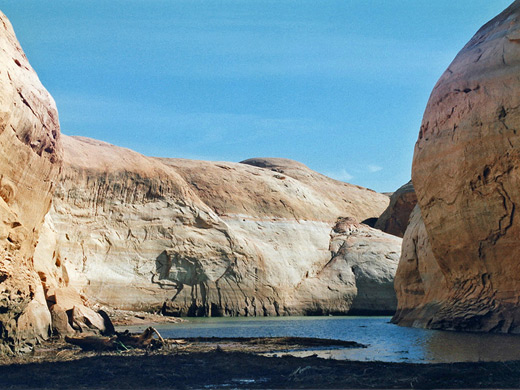
The next side canyon on the left becomes very dark and overhanging, a bit like Tunnel Slot in the Harris Wash drainage, then quite soon ends at a pool beneath an impassable dryfall and narrow crack above. A short distance further down the main channel is the original high water mark of Lake Powell at 3,700 feet elevation, though now the lake is long departed. There is one more tributary of passing interest, also on the left, above a deep pool and small waterfall, but this gains height quickly and disappears amongst the slickrock mounds above the rim. The lake waters begin around this junction, amidst more quicksand, smelly mud and thick mats of driftwood - although not very scenic at this point, the canyon system as a whole is one of the best in the Lake Powell region.
The easiest way back is to regress a little way up canyon, climb a diagonal slope strewn with small, dark pebbles of petrified wood, head west cross-country to intersect one of the dirt tracks near the canyon edge, then walk along here back towards UT 276.
Location
Smith Fork drains the southern slopes of Mount Ellsworth a few miles east of Bullfrog Marina and UT 276, and can be reached either by walking cross country from the highway or, if road conditions allow, by driving along one of several dirt tracks that cross the flat land around the canyon, in particular the first side track on the east after the crossing of Hansen Creek (about 2 miles south), which is 4 miles north of the Glen Canyon NRA boundary. There are plenty of good, free campsites hereabouts, including one a short distance along this track, a little way past a Utah highways depot. The left branch of the track crosses the creek - a point that may stop non-4WD vehicles - then bears east and later northeast towards a promontory called Danish Knoll. Turning right at a T-junction, the canyon is reached in another mile.
Photographs
17 views of Smith Fork Canyon.
Smith Fork Canyon Route Description
The full length of Smith Fork is around 15 miles though the upper reaches are shallow, and the most interesting part begins below a rockfall 3 miles from the high water mark of Lake Powell. The rockfall marks the point below which entry to Smith Fork, on the west side at least, is made difficult as the walls are generally too high and sheer, so the first objective is to head towards the canyon above the fall, descending perhaps along a small ravine just north of a distinctive rounded Navajo dome (marked 4140T on the topo map). Ahead, stretching away to the north and east lies a large area of more slickrock, crossed by several likely looking slot canyons though these are not very deep.
The main canyon is at first only a few meters wide and deep, already mostly vertical sided but not particularly notable until after the rock fall - this is a staged drop over three big boulders. The first two are simple to climb over while the lowest requires a jump of about 6 feet into mud, or maybe a pool, then after this the next easy exit back west is not until below the end of the narrows, quite close to the lake.
Tributary Slot Canyons
The canyon is now significantly deeper with only occasional routes out, via small tributaries on the east side, and offers mostly easy walking on a flat level floor of sand and small stones, with no vegetation. Occasional chokestones provide minor obstacles. The first east-side tributary is reached quite soon, and has similar forms and textures to Brimstone Gulch or Egypt 3, though shallower - it is just 18 inches wide in places, angled away from vertical, and is formed by dark rocks with knobbly inclusions and thin black bands running parallel to the streamway. It soon forks and opens out at the junction allowing egress to the slickrock above. The left branch begins with a nice small-scale swirling channel then deepens and for some distance forms another very narrow slot, sometimes requiring sideways movement to follow, always quite straight and with a base of pebbles or bare rock that often narrows to a sharp point and may harbor a few pools. A few small troublesome chokestones block the way, and these become more frequent further upstream. This passage remains about the same depth all along and while quite unusual, is not particularly photogenic. The right fork of the side canyon is too narrow to follow properly, is also quite long and a little less deep.
The Deepest Narrows
The main canyon continues south and is joined by another very narrow branch on the left, also not negotiable at ground level. Not far beyond the drainage turns west, deepens, and curves round a 180° bend - the best part of the slot, with colorful striated rocks, wavy walls and deep passages. They also have mud and pools, and are quite dark, rarely illuminated by sunlight. This part opens out into a graceful passageway with smooth walls streaked by desert varnish, which soon widens further, enough for sandbanks to form at either side while trees, reeds and grass start growing, all nourished by a small stream that begins to flow, and also creates patches of quicksand.
Lake Powell
The next side canyon on the left becomes very dark and overhanging, a bit like Tunnel Slot in the Harris Wash drainage, then quite soon ends at a pool beneath an impassable dryfall and narrow crack above. A short distance further down the main channel is the original high water mark of Lake Powell at 3,700 feet elevation, though now the lake is long departed. There is one more tributary of passing interest, also on the left, above a deep pool and small waterfall, but this gains height quickly and disappears amongst the slickrock mounds above the rim. The lake waters begin around this junction, amidst more quicksand, smelly mud and thick mats of driftwood - although not very scenic at this point, the canyon system as a whole is one of the best in the Lake Powell region.
Return Route
The easiest way back is to regress a little way up canyon, climb a diagonal slope strewn with small, dark pebbles of petrified wood, head west cross-country to intersect one of the dirt tracks near the canyon edge, then walk along here back towards UT 276.
Smith Fork - Similar Hikes
All Contents © Copyright The American Southwest | Comments and Questions | Contribute | Affiliate Marketing Disclosure | Site Map