Highlights:
The spectacular mountains of central California; well known national parks along the west side are Sequoia, Kings Canyon and Yosemite, while to the east, sites include Lake Tahoe and many lesser known scenic areas like Devils Postpile and the Big Pine Lakes
Type:
Loop, beginning at San Francisco
Length:
1,425 miles, 2,290 km
Duration:
13 days minimum; 18 days or more with optional side trips
Seasons:
Summer and fall, since all high elevation regions are closed by snow at other times
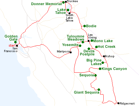
Map of the Sierra Nevada Itinerary
Please refer to the disclosure notice for information about the affiliate (commissionable) links on this page.
Day 1 - San Francisco to Truckee, 200 miles
The tour starts with the longest day of driving, all along Interstate 80, first to Donner Memorial State Park and then to Truckee for the night. The park commemorates one of the most famous episodes in the history of the west, when the Donner party became stranded in the Sierras during the snowy winter of 1846.
Day 2 - Truckee to South Lake Tahoe, 50 miles
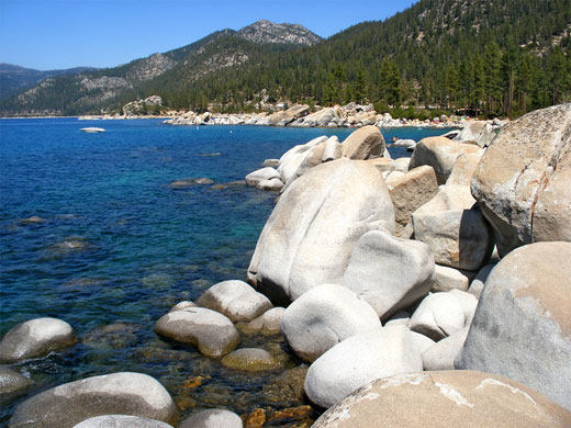
The second day is spent at beautiful Lake Tahoe, driving south along either the west or east shores. The east side is generally less developed, and much is contained within Lake Tahoe Nevada State Park, but the best scenery is in the west, especially in the southwest, centered on Emerald Bay State Park; this is gateway to the high elevation Desolation Wilderness, where hiking destinations include Lake Aloha and Velma Lake.
Optional extra day(s): more hiking in the Desolation Wilderness
Day 3 - South Lake Tahoe to Lee Vining, 160 miles
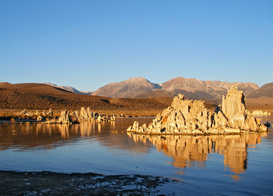
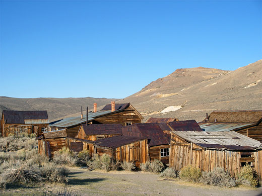
The quickest route south from Lake Tahoe is along US 395, which after Bridgeport passes the turning for the partly unpaved road to Bodie, the most authentic and best preserved ghost town in the West. A little further south, Mono Lake has much of interest to see including tufa formations, Panum Crater and the Black Point Fissures, while the nearby small town of Lee Vining has all necessary visitor facilities.
Hotel: Lake View Lodge, Lee Vining
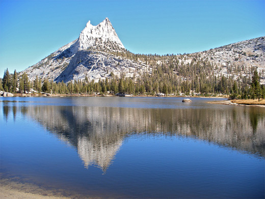
Day 4 - Tuolumne Meadows, Yosemite National Park, 50 miles
The east entrance to Yosemite National Park (Tuolumne Meadows) is just 12 miles from Lee Vining, and for the next 30 miles the highway passes many viewpoints and trailheads. There is enough to see for many days, but for just one, two recommended hikes are Cathedral Lakes and Gaylor Lakes.
Optional extra day(s): more hiking in Tuolumne Meadows
Hotel: Lake View Lodge, Lee Vining
Day 5 - Lee Vining to Bishop, 100 miles
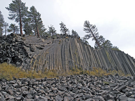
Continuing south along the eastern Sierra, the next attractions are Mammoth Lakes, Hot Creek (a collection of warm pools and occasional geysers), and Devils Postpile National Monument; this has unusual volcanic rocks, surrounded by pristine granite wilderness.
Day 6 - Bishop to Ridgecrest, 155 miles
At least half a dozen good roads climb steeply into the Sierras starting from US 395, leading to high elevation trailheads, from where the eastern crest is well within the range of a day hike; two good destinations are the Big Pine Lakes and Onion Valley. The nearest major town is Ridgecrest, at the edge of the Mojave Desert, which has a good selection of hotels.
Optional extra day(s): more hiking in the eastern Sierras, or an excursion to Death Valley
Day 7 - Ridgecrest to Sequoia National Park, 195 miles
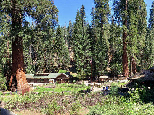
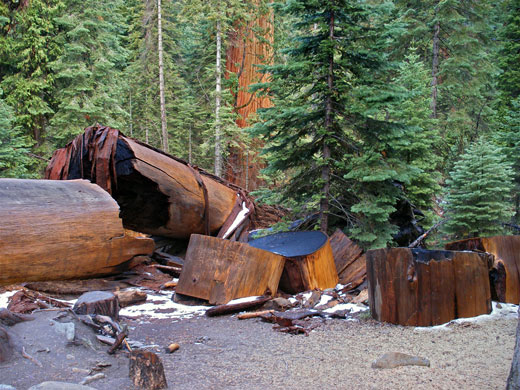
Hwy 178 cuts across the southern end of the Sierra Nevada, past Isabella Lake, from where the quickest way north is via Porterville, but a more scenic route (Hwy 190) heads higher into the mountains through the main section of Giant Sequoia National Monument, where several groves of the huge trees are viewable by short hikes. More winding roads head north and eventually reach the Giant Forest in Sequoia National Park, home of the largest trees on Earth.
Day 8 - Sequoia National Park to Kings Canyon National Park, 80 miles
Most of the day is spent in the Giant Forest, where suggested trails are Congress, Crescent Meadow and Huckleberry. A 60 mile drive northwards reaches Cedar Grove in the adjacent Kings Canyon National Park, on the floor of a spectacular glacial valley.
Optional extra day: more hiking in Sequoia National Park
Hotel: Cedar Grove Lodge, within Kings Canyon National Park
Day 9 - Kings Canyon National Park, 20 miles
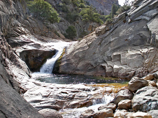
A full day is spent in Kings Canyon, where three good short hikes are Roaring River Falls, Zumwalt Meadows and the lower end of Hotel Creek, while the best of the longer hikes is to Mist Falls.
Hotel: Cedar Grove Lodge, within Kings Canyon National Park
Day 10 - Kings Canyon National Park to Oakhurst, 130 miles
The Grant Grove section of Kings Canyon NP features more giant sequoia, including the famous General Grant; other photogenic locations hereabouts are Big Stump Basin and Buena Vista Peak . The road east (CA 180) descends from the mountains and leads to Fresno, from where Oakhurst at the gateway to Yosemite National Park is a quick 50 mile drive northwards. A more scenic route, similar in distance but much more winding, follows the foothills northwestwards, past such places as Pine Flat Lake, Auberry and Bass Lake.Day 11 - Oakhurst to Yosemite Valley, 60 miles
The southernmost section of Yosemite National Park is Mariposa, site of a grove of giant sequoia. Nearby Wawona has a few trails including to Chilnualna Falls, but the main section of the park is Yosemite Valley, 20 miles north, one of the most immediately spectacular places in the West.
Hotel: Yosemite Valley Lodge
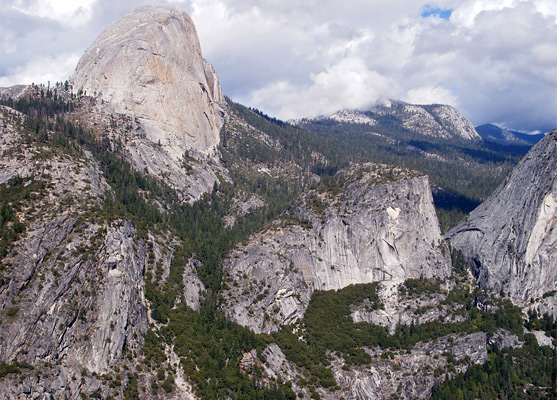
Day 12 - Yosemite Valley to Mariposa, 45 miles
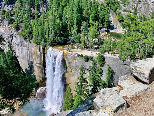
Most of the day is spent in Yosemite Valley, where amongst the many popular trails are Vernal Fall, Nevada Fall, Mirror Lake and Lower Yosemite Fall. The peaceful town of Mariposa in the western mountain foothills offers several good hotels.
Optional extra day(s): more hikes in Yosemite Valley, and/or locations along Glacier Point Road
Day 13 - Mariposa to San Francisco, 180 miles
The long journey back to San Francisco is on quick roads (Hwy 99, I-205 and I-580), allowing time at some of the many sites of Golden Gate National Recreation Area, such as the tall trees of Muir Woods National Monument.
All Contents © Copyright The American Southwest | Comments and Questions | Contribute | Affiliate Marketing Disclosure | Site Map