Bridal Veil Falls and Ingram Basin, San Juan Mountains
Colorado > San Juan Mountains > Bridal Veil Falls and Ingram Basin
Bridal Veil Falls and Ingram Basin
Exploration of the high mountains east of Telluride - to a 385 foot waterfall, an Alpine basin and a narrow ridge at 12,860 feet, overlooking the Red Mountain mining district. Accessible to hikers or 4WD vehicles. Optional off-trail return route via a 13,477 summit and another basin to the south
Length: 3.8 miles (one way) to the ridge above Ingram Basin; 8.8 miles for the loop returning via Mud Lake Basin
Elevation change: 3,800 feet, or 4,430 feet for the loop
Difficulty: Strenuous
Type: One way, or loop
Usage: High to Bridalveil Falls; medium to the ridge (mostly 4WD vehicles), low for the off trail hike
Season: Summer and fall
Trailhead: East end of Colorado Avenue in Telluride, near Pandora Mine
Rating (1-5): ★★★★★

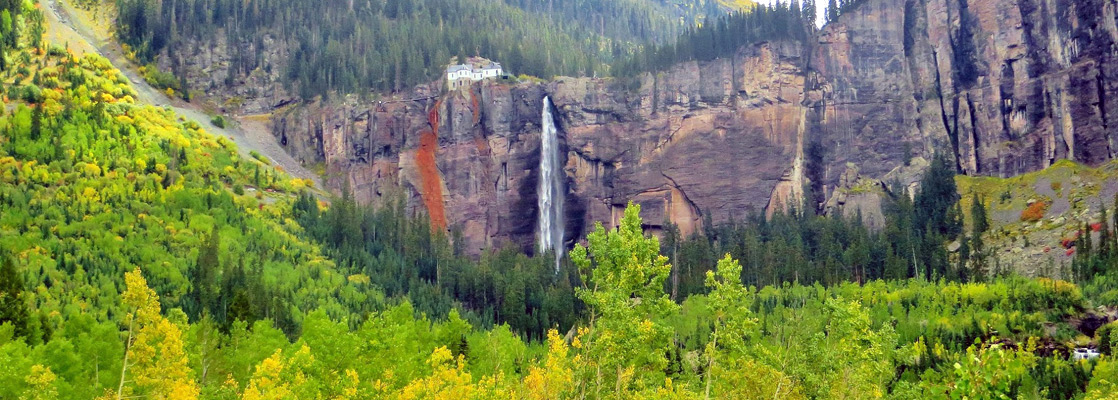
An extensive network of jeep tracks and former mining roads cross the middle of the western half of the San Juan Mountains, and one of the most travelled routes links Telluride with Red Mountain Pass on US 550, most of which is one-way (east to west). The lower section near Telluride is also popular for hiking and cycling, and a walk up here leads visitors to the 385 foot high Bridal Veil Falls, several old mines, a peaceful Alpine valley (Ingram Basin) and eventually a narrow ridge overlooking a vast area of the San Juan range and the colorful Red Mountain mining district.
One option for continuing the hike, off trail, is to climb southwards to a nearby peak at 13,477 feet, returning down an adjacent valley (Mud Lake Basin) past a pool and a stream with pretty cascades, then along a wooded ravine back to near the start of the jeep trail.
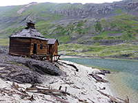
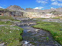
The hike begins at 9,000 feet, at the end of the paved section of Bridal Veil Falls Road, 2 miles east of Telluride and just after the road passes through the still active Pandora Mine. 4WD vehicles may be driven 2 miles further to the top of the waterfall, then beyond is the one-way section. For those on foot it takes about 30 minutes walking up the wooded hillside to reach the base of the falls then another 20 minutes to the top. A restored but privately-owned pumping station sits beside the stream on the cliff edge though there is a path beside it, following Bridal Veil Creek. The jeep track switchbacks sharply up the head of the main valley and offers increasingly good views over Telluride far below. It crosses a fast-flowing stream (Ingram Creek) then winds round the side of a steep, exposed cliff face, quite a treacherous section even for 4WD vehicles (Black Bear Pass), and then, now at an elevation of 11,200 feet, leads into Ingram Basin - a wide, quite flat valley carpeted by moss, heather, and long grass mixed with wildflowers in spring.
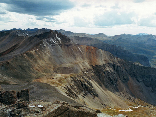
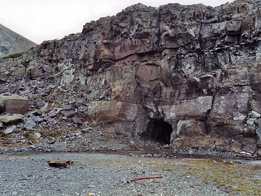
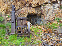
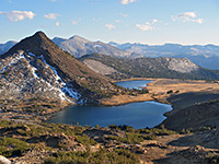
The surrounding hills have a number of spoil heaps and unsealed old mine tunnels, though exploring these is not recommended. From the edge of the basin, another 90 minutes hiking either along the jeep trail or in a straight line across the valley and up some cliffs on the south side leads to the highest point on the road, a ridge at 12,860 feet, which has quite spectacular views eastwards over the brightly colored volcanic peaks of the Red Mountain district and countless more distant summits.
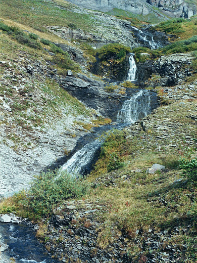
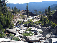
The ridge is an obvious point to turn around, but an alternative way back is to first climb to the summit just to the southwest, an unnamed peak at 13,477 feet - even better views from here - then climb down the steep slope on the far side and into the adjacent valley (Mud Lake Basin), upper end of which does indeed contain a shallow, muddy lake. A stream flows from here and tumbles down a rocky hillside forming a number of pretty waterfalls and cascades. Further down it joins with Bridal Veil Creek, and the jeep trail is reached again after another 2 miles walking down the canyon. The round trip takes about 5 hours.
One option for continuing the hike, off trail, is to climb southwards to a nearby peak at 13,477 feet, returning down an adjacent valley (Mud Lake Basin) past a pool and a stream with pretty cascades, then along a wooded ravine back to near the start of the jeep trail.
Bridal Veil Falls
The hike begins at 9,000 feet, at the end of the paved section of Bridal Veil Falls Road, 2 miles east of Telluride and just after the road passes through the still active Pandora Mine. 4WD vehicles may be driven 2 miles further to the top of the waterfall, then beyond is the one-way section. For those on foot it takes about 30 minutes walking up the wooded hillside to reach the base of the falls then another 20 minutes to the top. A restored but privately-owned pumping station sits beside the stream on the cliff edge though there is a path beside it, following Bridal Veil Creek. The jeep track switchbacks sharply up the head of the main valley and offers increasingly good views over Telluride far below. It crosses a fast-flowing stream (Ingram Creek) then winds round the side of a steep, exposed cliff face, quite a treacherous section even for 4WD vehicles (Black Bear Pass), and then, now at an elevation of 11,200 feet, leads into Ingram Basin - a wide, quite flat valley carpeted by moss, heather, and long grass mixed with wildflowers in spring.
The Summit
The surrounding hills have a number of spoil heaps and unsealed old mine tunnels, though exploring these is not recommended. From the edge of the basin, another 90 minutes hiking either along the jeep trail or in a straight line across the valley and up some cliffs on the south side leads to the highest point on the road, a ridge at 12,860 feet, which has quite spectacular views eastwards over the brightly colored volcanic peaks of the Red Mountain district and countless more distant summits.
The Return Route
The ridge is an obvious point to turn around, but an alternative way back is to first climb to the summit just to the southwest, an unnamed peak at 13,477 feet - even better views from here - then climb down the steep slope on the far side and into the adjacent valley (Mud Lake Basin), upper end of which does indeed contain a shallow, muddy lake. A stream flows from here and tumbles down a rocky hillside forming a number of pretty waterfalls and cascades. Further down it joins with Bridal Veil Creek, and the jeep trail is reached again after another 2 miles walking down the canyon. The round trip takes about 5 hours.
Bridal Veil Falls and Ingram Basin - Similar Hikes
All Contents © Copyright The American Southwest | Comments and Questions | Contribute | Affiliate Marketing Disclosure | Site Map