CALIFORNIA


Map of Lassen Volcanic National Park


Sites in California

NPS Units
Cabrillo
Death Valley
Devils Postpile
Golden Gate
Joshua Tree
Kings Canyon
Lassen Volcanic
Lava Beds
Mojave
Muir Woods
Pinnacles
Point Reyes
Redwood
Santa Monica Mnts
Sequoia
Whiskeytown-Shasta
Yosemite

Other Places
Anza-Borrego Desert
Big Basin Redwoods
Big Sur
Bodie SHP
Calaveras Big Trees
California Missions
Humboldt Redwoods
Lake Tahoe
Palm Springs
Point Lobos

California Site Map

Follow americansouthwest.net on Facebook
Site Search

Photograph Search


Lassen Volcanic National Park > Map

Lassen Volcanic National Park Map


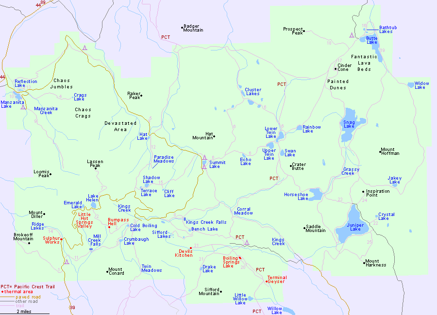
Trails are identified by a number, corresponding to the description on the trail listings page.

The main (south) entrance to Lassen Volcanic National Park along Highway 89 is 52 miles from Red Bluff on interstate 5, 150 miles from Reno and 150 miles from Sacramento. The north entrance by Manzanita Lake is 50 miles east of Redding.

PDFPDF format map of Lassen Volcanic National Park, from the National Park Service (6.5 mb). This is larger in filesize than most NPS maps, because of its background imagery.

Back to Top

All Contents © Copyright John Crossley | Comments and Questions | Site Map

Arizona California Colorado Nevada New Mexico Oregon Texas Utah Wyoming Slot Canyons Travelogue