Bill Williams River Canyon and Ives Wash
Arizona > Bill Williams River > Bill Williams River Canyon and Ives Wash
Bill Williams River Canyon and Ives Wash
Narrow, desert canyon in a remote part of Arizona, accessible at the upper end from Alamo Lake State Park. Hike follows a road then a trail alongside the river, ending at an enclosed section. Continuing further downstream is possible, via a combination of wading and climbing, while the tributary of Ives Wash contains narrower passageways, through photogenic, metamorphic rocks
Length:5 miles, round trip, or longer
Elevation change: 300 feet
Difficulty: Moderate to strenuous - scrambling, route-finding
Type: One way or partial loop
Usage: Very low
Season: Fall and spring are best
Trailhead: Near the end of the paved road to Alamo Dam
Rating (1-5): ★★★★★
Elevation change: 300 feet
Difficulty: Moderate to strenuous - scrambling, route-finding
Type: One way or partial loop
Usage: Very low
Season: Fall and spring are best
Trailhead: Near the end of the paved road to Alamo Dam
Rating (1-5): ★★★★★

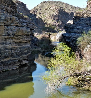
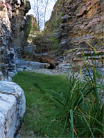
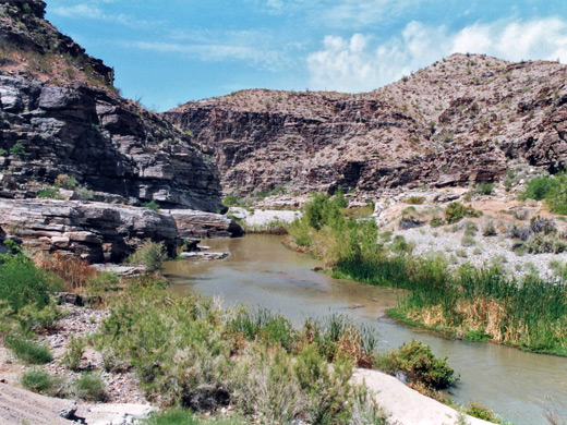
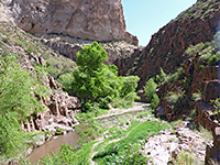
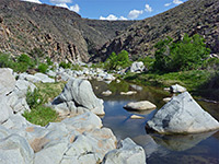
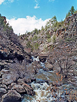
The east (upper) end of the scenic, rocky, rugged canyon of the Bill Williams River may be accessed from the paved road to Alamo Lake State Park, near Alamo Dam. Soon after the gate near the end of this road, the route forks; one branch crosses the top of the dam while the other winds down around cliffs and through an open area, finally ending where the canyon begins to narrow, about one mile from the gate. Nearby is a gaging station and remains of a cable car crossing of the river. A path continues, initially along a sandy bank above the river, which soon enters an enclosed, 600 foot section with vertical walls and deep water.
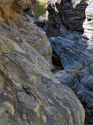
To continue, one option is to wade or at times swim through the river, but the water is not very clean and smells bad, supposedly due to farming wastes concentrated in the reservoir then released from the dam, and also has patches of deep, soft mud. So, climbing rocks at either side is probably best, and this is easiest on the left (south) as to the right the cliffs are higher and more vertical. On both sides are occasional old wooden ladders leading to tunnels, relics from mining activities early last century.
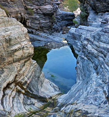
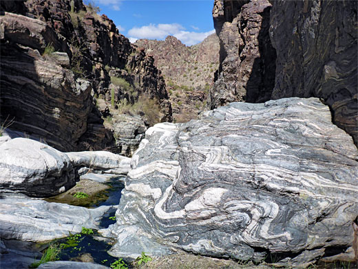
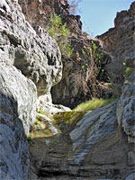
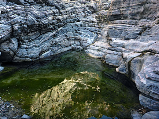
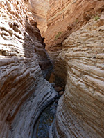
Also of interest is a south-side tributary, Ives Wash, the lower end of which contains a small but permanent, spring-fed stream, flowing through a quarter mile-long narrows section - a slot canyon - framed by layered, metamorphic rocks of black gneiss and white marble. Along the way are several pools and dryfalls, but it is easy enough to progress all the way through the narrows, above which the canyon opens out abruptly.
The hike begins from Bill Williams Overlook, on a little hill a third of a mile from Alamo Dam, with sweeping views all along the lake. The onwards road is gated, marked as private, but accessible to hikers - it descends the hillside and ends at the gaging station, from where a path continues, through tamarisk and other scrub beside the Bill Williams River and across an open, stony area to the point where Ives Wash joins from the south and the river becomes cliff-bound, at the start of its canyon. To proceed without swimming or floating requires quite a lengthy climb up the steep, crumbling slopes just west of Ives Wash, down into a little valley that drops off steeply to the river, and up again to a ridgetop, a good viewpoint of the canyon. Ahead is a long slope that allows a straightforward descent back to river level.
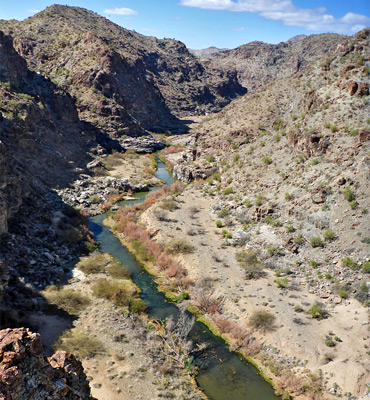
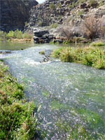
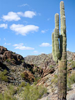
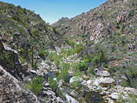
Downstream, the canyon becomes up to 600 feet deep but stays generally quite wide, with sand and pebble banks beneath the cliffs (plenty of places for primitive camping), grassy areas and bushes closer to the waters edge, and many cacti growing on the rocky hillsides. A faint path follows the river on the south side, although some rockier sections need a little climbing, and/or crossing to the north. Occasional V-shaped side canyons join, and the character remains similar for about 5 miles, where the hills recede and the river enters a much wider valley. The rocks are metamorphic and rather weathered, with interesting colors, patterns and textures. The canyon is the main attraction of the Rawhide Mountains Wilderness, a 38,000 acre expanse of remote peaks and ravines.
Ives Wash is a relatively long tributary, six miles, mostly shallow and open, enclosed only at the lower end, for a quarter of a mile. Near the mouth is a small dryfall, easily climbed, soon followed by a second drop, not steep though smooth and slippery; a rope may be left in place to aid the climb. The stream bends slightly to the left, after a third drop, and flows through a pretty, oval pool, then next are more narrow passageways containing a few smaller falls and pools, the last one rather muddy as the canyon becomes briefly overgrown, opens out, and is usually dry. All the rocks in the narrows are extravagantly banded - migmatitic layered gneiss, dark gray in color, crossed by many veins of white marble, the strata often compressed and distorted into swirling shapes.
To continue, one option is to wade or at times swim through the river, but the water is not very clean and smells bad, supposedly due to farming wastes concentrated in the reservoir then released from the dam, and also has patches of deep, soft mud. So, climbing rocks at either side is probably best, and this is easiest on the left (south) as to the right the cliffs are higher and more vertical. On both sides are occasional old wooden ladders leading to tunnels, relics from mining activities early last century.
Also of interest is a south-side tributary, Ives Wash, the lower end of which contains a small but permanent, spring-fed stream, flowing through a quarter mile-long narrows section - a slot canyon - framed by layered, metamorphic rocks of black gneiss and white marble. Along the way are several pools and dryfalls, but it is easy enough to progress all the way through the narrows, above which the canyon opens out abruptly.
The River
The hike begins from Bill Williams Overlook, on a little hill a third of a mile from Alamo Dam, with sweeping views all along the lake. The onwards road is gated, marked as private, but accessible to hikers - it descends the hillside and ends at the gaging station, from where a path continues, through tamarisk and other scrub beside the Bill Williams River and across an open, stony area to the point where Ives Wash joins from the south and the river becomes cliff-bound, at the start of its canyon. To proceed without swimming or floating requires quite a lengthy climb up the steep, crumbling slopes just west of Ives Wash, down into a little valley that drops off steeply to the river, and up again to a ridgetop, a good viewpoint of the canyon. Ahead is a long slope that allows a straightforward descent back to river level.
The Canyon
Downstream, the canyon becomes up to 600 feet deep but stays generally quite wide, with sand and pebble banks beneath the cliffs (plenty of places for primitive camping), grassy areas and bushes closer to the waters edge, and many cacti growing on the rocky hillsides. A faint path follows the river on the south side, although some rockier sections need a little climbing, and/or crossing to the north. Occasional V-shaped side canyons join, and the character remains similar for about 5 miles, where the hills recede and the river enters a much wider valley. The rocks are metamorphic and rather weathered, with interesting colors, patterns and textures. The canyon is the main attraction of the Rawhide Mountains Wilderness, a 38,000 acre expanse of remote peaks and ravines.
Ives Wash
Ives Wash is a relatively long tributary, six miles, mostly shallow and open, enclosed only at the lower end, for a quarter of a mile. Near the mouth is a small dryfall, easily climbed, soon followed by a second drop, not steep though smooth and slippery; a rope may be left in place to aid the climb. The stream bends slightly to the left, after a third drop, and flows through a pretty, oval pool, then next are more narrow passageways containing a few smaller falls and pools, the last one rather muddy as the canyon becomes briefly overgrown, opens out, and is usually dry. All the rocks in the narrows are extravagantly banded - migmatitic layered gneiss, dark gray in color, crossed by many veins of white marble, the strata often compressed and distorted into swirling shapes.
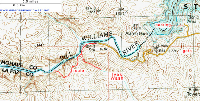
Topographic Map
Bill Williams River Canyon and Ives Wash - Similar Hikes
All Contents © Copyright The American Southwest | Comments and Questions | Contribute | Affiliate Marketing Disclosure | Site Map